Bicentennial Trail
check with the trail manager for updated details before visiting.
Bicentennial Trail
City, Town, or County
Backcountry Trail
- Length
3.2 miles
- Elevation Gain
--
- Route Type
out & back
- Length
3.2 miles - Elevation Gain
-- - Route Type
out & back
The Bicentennial Trail offers scenic vista views, mountain views, oak and maple forests, tall evergreens, sagebrush fields, water features (reservoir, streams and beaver dams).
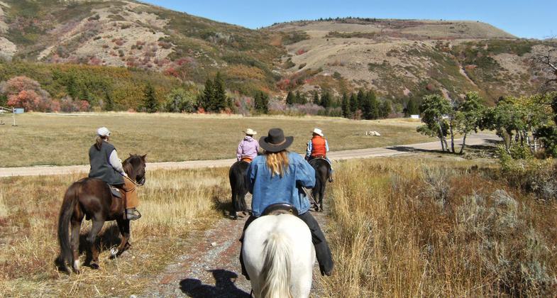
Photo by Judy Nelson.

Spectacular trail views!. Photo by Judy Nelson.

Equestrians enjoying a fall ride. Photo by Judy Nelson.

This is one of our very favorite trails. Can be ridden from about mid-April whenever the snow is gone to October 31 when it cl. Photo by Judy Nelson.
Location: Cutler Flats camp area, part of North Fork Park.
- States: Utah
The Bicentennial Trail was built in 1976 in commemoration of the Bicentennial of the United States. The trail is accessed through the Cutler Flats camp area, part of North Fork Park. The trail begins as the North Fork River Trail with a turn-off for the Bicentennial. The Bicentennial Trail travels through national forest and private property. The trail offers scenic vista views, mountain views, oak and maple forests, tall evergreens, sagebrush fields, and water features (reservoirs, streams, and beaver dams). It is a favorite of hikers, bicyclists, and equestrians.
Accessibility Information
No text provided.
Allowed Uses:
Bicycling Equestrian Hiking/WalkingPublic Contact
Weber County Planning Commission13th Floor
Ogden, UT 84401
Contact the trail manager for current maps and visiting details.
More Details
- Elevation (low): --
- Elevation (high): --
- Elevation (cumulative): --
- Part of a Trail System? No
- Surface (primary): --
- Surfaces (additional): --
- Tread Width (average): 0"
- Tread Width (minimum): --
- Running length (minimum): --
- Tread Grade (average, percent): --
- Tread Grade (maximum):
- Running length (maximum): --
- Cross-slope (average, percent): --
- Cross-slope (maximum): --
- Running length (maximum): --
- Certified as an NRT
Nov 26, 1981