Cedar Falls
check with the trail manager for updated details before visiting.
Cedar Falls
State
Backcountry Trail
- Length
2.2 miles
- Elevation Gain
--
- Route Type
out & back
(1 review)
- Length
2.2 miles - Elevation Gain
-- - Route Type
out & back
The first half mile descends more than 200 feet down steps cut from rock by the Civilian Conservation Corps more than 60 years ago.

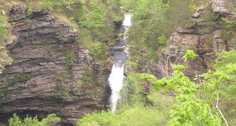
View of Cedar Falls from the overlook in Petit Jean State Park . Photo by ErgoSum88/wiki.
Location: Petit Jean State Park, 21 miles south of Morrillton, starts at Mather Lodge.
- States: Arkansas
The trail follows beautiful Cedar Creek another half mile to the climax of the hike, Cedar Falls, one of the state's most spectacular sights. Cedar Falls cascades more than 90 feet to the canyon floor. Cedar Creek Canyon was added to the register of Arkansas Natural Areas in 1977.
Accessibility Information
No text provided.
Reviews
Hiker Jim
Spectacular - but difficult
When the falls are flowing, this is one of the prettier spots in Arkansas. But be forewarned, it is a steep hike down, and of course even steeper climbing out.
Allowed Uses:
Hiking/WalkingPublic Contact
Petit Jean State Park1285 Petit Jean Mountain Road
Morrilton, AR 72110
(501) 727-5441
www.petitjeanstatepark.com
Contact the trail manager for current maps and visiting details.
More Details
- Elevation (low): --
- Elevation (high): --
- Elevation (cumulative): --
- Part of a Trail System? No
- Surface (primary): Soil
- Surfaces (additional): --
- Tread Width (average): 0"
- Tread Width (minimum): --
- Running length (minimum): --
- Tread Grade (average, percent): --
- Tread Grade (maximum):
- Running length (maximum): --
- Cross-slope (average, percent): --
- Cross-slope (maximum): --
- Running length (maximum): --
- Certified as an NRT
Mar 7, 1978

