Devil's Head
This information is a public record of the 1979 NRT application and may be out of date if it has not been updated by a trail manager --
check with the trail manager for updated details before visiting.
check with the trail manager for updated details before visiting.
Devil's Head
USDA Forest Service
- Length
1.3 miles
- Elevation Gain
--
- Route Type
out & back
- Length
1.3 miles - Elevation Gain
-- - Route Type
out & back
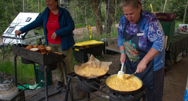
2023 Photo Contest Winner: Youth and Volunteers. Photo by Jay Poules

Volunteers for Outdoor Colorado performing trail maintenance

Volunteers for Outdoor Colorado performing trail maintenance

Volunteers for Outdoor Colorado performing trail maintenance

Stairs leading up to Devil's Head Lookout in Colorado. The tower is visible in the upper right corner. Photo by Glennfcowan/wiki.

The view from the Devil's Head Lookout. Photo by Glennfcowan/wiki.

Picture of lookout tower at Devil's Head, Colorado. Pike's Peak is visible in the background. Photo by Glennfcowan/wiki.
Location: In the Pike NF at Devil's Head Campground. From Sedalia take US 85 and SR 7 W 10 mi. to Indian Creek Work Center. Then 9 mi. S on Rampart Range Rd.
- States: Colorado
The trail leads to a fire lookout with 360-degree views of Pike National Forest, plains. Interpretative signs along trail explaining the role of forest fires. Climb 948 ft through Ponderosa pine/douglas fir forest, to granite outcrop.
Accessibility Information
No text provided.
Allowed Uses:
Hiking/WalkingOther Activities
- Camping
Public Contact
Pike-San Isabel National Forest1920 Valley Dr.
Pueblo, CO 81008
Contact the trail manager for current maps and visiting details.
More Details
- Elevation (low): --
- Elevation (high): --
- Elevation (cumulative): --
- Part of a Trail System? No
- Surface (primary): --
- Surfaces (additional): --
- Tread Width (average): 0"
- Tread Width (minimum): --
- Running length (minimum): --
- Tread Grade (average, percent): --
- Tread Grade (maximum):
- Running length (maximum): --
- Cross-slope (average, percent): --
- Cross-slope (maximum): --
- Running length (maximum): --
- Certified as an NRT
Nov 15, 1979