Drinking Horse Mountain Trail
check with the trail manager for updated details before visiting.
Drinking Horse Mountain Trail
U.S. Fish and Wildlife Service
Backcountry Trail
- Length
2.2 miles
- Elevation Gain
--
- Route Type
Loop
- Length
2.2 miles - Elevation Gain
-- - Route Type
Loop
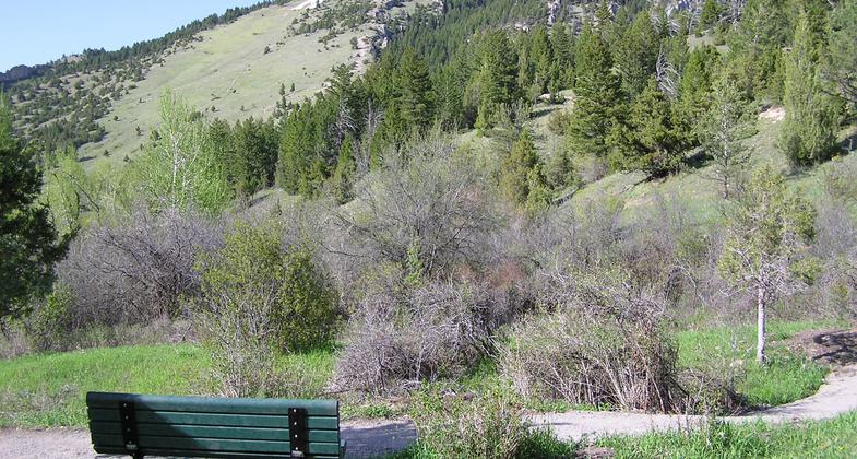
The 2.2 mile figure-eight loop trail climbs 700 feet from Bridger Creek through diverse vegetation and terrain, to the summit of Drinking Horse Mountain. A unique covered bridge serves as a beautiful gateway for the trail and eight memorial benches and one memorial picnic table offer scenic vistas of the Gallatin Valley.

Pasture bench. Photo by Molly Webb.

Photo by Ellen Kress.

Summit ridge. Photo by Molly Webb.

Photo by Ellen Kress.

Photo by Ellen Kress.
Location: Trailhead located at the Bozeman Fish Technology Center, 4 miles east of Bozeman, Montana along Bridger Canyon Road 86.
- States: Montana
- Counties: Gallatin
The 2.2-mile figure-eight loop trail climbs 700 feet from Bridger Creek through diverse vegetation and terrain, to the summit of Drinking Horse Mountain. A unique covered bridge serves as a beautiful gateway for the trail and eight memorial benches and one memorial picnic table offer scenic vistas of the Gallatin Valley.
Look left as you drive out of Bridger Canyon and you'll see a mountain shaped like a horse drinking from a creek. When the owners called us and said they wanted to donate this property, we knew we had an opportunity to create something special. Adjacent to land owned by the United States Forest Service and US Fish & Wildlife Service (USFWS), with an ascent that offers spectacular views in four directions, the parcel was perfectly positioned for a new trail. Gallatin Valley Land Trust (GVLT) helped facilitate the donation of the land to USFWS and raised money from the community to create two routes at the top and install the locally-designed Kevin Mundy Memorial Bridge, named after a local ski patroller.
All told it took GVLT and our partners eight years to permit, design, fund, and construct the Drinking Horse Mountain trail, but it was well worth the wait. Families with young children enjoy the short trek to the bright-orange bridge. Designed with seating so it can serve as an outdoor classroom, the structure makes the perfect creek-side picnic spot. Stronger hikers can continue up the trail 700 vertical feet up for a show-stopping view into Bridger Canyon and back across the valley.
The Drinking Horse Mountain Trail is one of the most popular trails in the Gallatin Valley thanks to its location within a 5-minute drive of downtown Bozeman, its easy access, and the high-quality experience it provides in a conveniently moderate distance.
From willows and cottonwoods along Bridger Creek to rocky outcrops, evergreen forest, and wildflower-decorated hillsides, the Drinking Horse Mountain Trail offers great variety in a 2.2-mile figure-eight loop. The variety of vegetation provides a great opportunity for wildlife viewing, bird watching, and the study of nature. The figure-eight trail design has a steep route for those who desire more intense aerobic exercise and an easier path for those who seek a leisurely stroll. Dogs often bring their best human friends for some exercise and are pleased to find two dog sanitation stations for their convenience and plenty of cold water to drink in Bridger Creek.
Two information kiosks are located along the trail to provide etiquette information and maps to help orient new users to the trail. Eight memorial benches and one picnic table made from recycled plastic are located along the trail and offer a well-deserved respite with spectacular views of the Gallatin Valley, Bridger Canyon, and surrounding mountain ranges.
The Drinking Horse Mountain Trail provides an alternative destination to the popular and often crowded "Foothills" and "M" trails which are administered by the USFS and located directly across Bridger Canyon Road. Parking at the trailhead for these trails often overflows onto the road and one of the goals of creating the Drinking Horse Mountain Trail was to spread out this heavy use.
Accessibility Information
No text provided.
Allowed Uses:
Dogs, on leash Hiking/WalkingPublic Contact
Robert MuthU.S. Fish and Wildlife Service
4050 Bridger Canyon Road
Bozeman, MT 59715
[email protected] • (406) 587-9265
www.fws.gov/bozemanfishtec
Contact the trail manager for current maps and visiting details.
More Details
- Elevation (low): 4840
- Elevation (high): 5539
- Elevation (cumulative): --
- Part of a Trail System? No
- Surface (primary): Soil
- Surfaces (additional): Paved, Rock, crushed
- Tread Width (average): 48"
- Tread Width (minimum): --
- Running length (minimum): --
- Tread Grade (average, percent): 10
- Tread Grade (maximum): 30
- Running length (maximum): --
- Cross-slope (average, percent): --
- Cross-slope (maximum): --
- Running length (maximum): --
- Certified as an NRT
May 2, 2010

