Dripstone Trail
check with the trail manager for updated details before visiting.
Dripstone Trail
USDA Forest Service
Backcountry Trail
- Length
0.4 miles
- Elevation Gain
--
- Route Type
out & back
- Length
0.4 miles - Elevation Gain
-- - Route Type
out & back
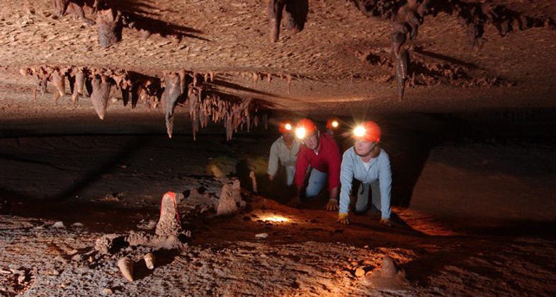
The Dripstone Trail tour travels through two huge rooms filled with an incredible variety and number of crystalline formations - sparkling flowstone, towering columns, and delicate soda straws.
Location: Blanchard Caverns, Ozark Mountains near Fifty-Six, AR
- States: Arkansas
- Counties: Stone
The Dripstone Trail tours are available year-round. The time you should allow for this tour is 1 hour. On this tour, you will experience a constant 58 degrees F (so bring a sweater or light jacket), and know that the humidity is close to 100 percent. This trail is accessible to strollers and wheelchairs with strong assistance. This tour covers 4/10 of a mile in an hour. It is an easy walk with two seating areas along the trail for you to rest should you need to. There are only 50 stair steps to be negotiated on the entire tour but for those that can not manage them, there are alternate trails that can be used, bypassing some formations. In this section of the cave, bats are rare so don't worry about running into them.
The Dripstone Trail tour travels through two huge rooms filled with an incredible variety and a number of crystalline formations - sparkling flowstone, towering columns, and delicate soda straws. There are tiny cave creatures such as salamanders and crickets for you to see. You will be able to see nearly every type of calcite formation found in limestone caves. This includes delicate, hollow soda straws to massive flowstones and stalagmites. You will be touring the two major rooms on the upper level of the cavern system. The cathedral Room is long enough to hold three football fields and still has space left over. There are many snow-white formations of pure calcite (or calcium carbonate) in the Coral Room. You are walking through an area that was laid down in an ancient sea more than 350 million years ago. These beautiful formations have taken years to be made, no one knows for sure how long it has taken but maybe thousands, hundreds of thousands, or millions of years for the dripping water to deposit the calcite and other minerals into these fabulous formations. A vast amount of dripstone is found in this portion of the Caverns for two reasons. First, this section is higher than the other, allowing air-chemistry changes which cause the dripstone to form, and second, this portion is older than lower areas, giving the features more time to develop.
Accessibility Information
No text provided.
Allowed Uses:
Hiking/WalkingOther Activities
- Caving
- Heritage and history
- Wildlife viewing / observation
Public Contact
Tracy FarleyOzark-St. Francis National Forest
605 W. Main St.
Russellville, AR 72801
[email protected] • (501) 964-7231
Contact the trail manager for current maps and visiting details.
More Details
- Elevation (low): --
- Elevation (high): --
- Elevation (cumulative): --
- Part of a Trail System? No
- Surface (primary): Paved
- Surfaces (additional): Paved
- Tread Width (average): 48"
- Tread Width (minimum): 38
- Running length (minimum): --
- Tread Grade (average, percent): 5
- Tread Grade (maximum): 8
- Running length (maximum): --
- Cross-slope (average, percent): 2
- Cross-slope (maximum): --
- Running length (maximum): --
- Certified as an NRT
Aug 21, 1978


