Escudilla Trail
check with the trail manager for updated details before visiting.
Escudilla Trail
USDA Forest Service
- Length
3.3 miles
- Elevation Gain
--
- Route Type
out & back
- Length
3.3 miles - Elevation Gain
-- - Route Type
out & back
The three-mile maintained Escudilla National Recreation Trail #308, approaches the summit of Escudilla Mountain from the Terry Flat Loop Road and leads to a fire lookout tower, the highest tower in the state.
Location: In Apache National Forest at Escudilla Mountain, southeast of Eagar.
- States: Arizona
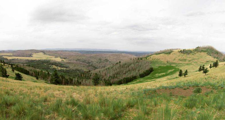
The Escudilla Wilderness encompasses the upper reaches of the mountain, which at 10,912 feet is the third highest in the state of Arizona. It was this mountain that Aldo Leopold referred to in his article "Thinking Like a Mountain" where he arrived at the side of a wolf he had shot "in time to watch a fierce green fire dying in her eyes," an experience that he grew to regret and which forever changed his life. The last known grizzly bear in Arizona was killed here, and Leopold wrote: "Somehow it seems that the spirit of the bear is still there, prowling the huge meadows, lurking in the thick stands of aspen and spruce, wandering the steep slopes that looking down from is like looking out of the window of an airplane."
Two trails give access to Escudilla Wilderness. The three-mile maintained Escudilla National Recreation Trail #308, approaches the summit from the Terry Flat Loop Road and leads to a fire lookout tower, the highest tower in the state. Government Trail #119 starts at the base of the mountain and also climbs to the summit as it ascends to Profanity Ridge. You will find little water along these trails, but views that reach Flagstaff 100 miles away.
The Escudilla Wilderness has been severely affected by the Wallow Fire of June 2011. The area is currently open to public use and entry, but trails may not be assessed or maintained for hazards associated with the fire. The Escudilla Lookout was severely damaged by the fire and is closed to all public entry due to safety concerns.
Accessibility Information
No text provided.
Allowed Uses:
Hiking/WalkingPublic Contact
Apache-Sitgreaves National ForestFederal Building
Springerville, AZ 85938
Contact the trail manager for current maps and visiting details.
More Details
- Elevation (low): --
- Elevation (high): --
- Elevation (cumulative): --
- Part of a Trail System? No
- Surface (primary): --
- Surfaces (additional): --
- Tread Width (average): 0"
- Tread Width (minimum): --
- Running length (minimum): --
- Tread Grade (average, percent): --
- Tread Grade (maximum):
- Running length (maximum): --
- Cross-slope (average, percent): --
- Cross-slope (maximum): --
- Running length (maximum): --
- Certified as an NRT
Dec 7, 1978


