Flint River Water Trail
check with the trail manager for updated details before visiting.

Flint River Water Trail
Nonprofit
National Water Trail
- Length
73 miles
- Elevation Gain
--
- Route Type
out & back
- Length
73 miles - Elevation Gain
-- - Route Type
out & back
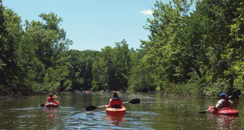
The Flint River Water Trail (FRWT) is a 73-mile water trail that provides a variety of recreational experiences and opportunities by connecting users to natural, cultural, and historic features along a safe and accessible river trail. It brings about awareness for stewardship of the Flint River and surrounding lands. The water trail crosses through two counties, natural areas, and an urban core, and is available to hundreds of thousands of residents within an hour's drive.
Location: Begins in City of Lapeer, southwest portion of Lapeer County and ends in Montrose Township, northwest Genesee County.
- States: Michigan
- Counties: Lapeer, Genesee
- Cities/Townships: Lapeer, Mayfield, Oregon, Marathon, Columbiaville, Richfield, & Genesee Twps., Flint, Flushing, Montrose Twp.
The Flint River Water Trail (FRWT) is a 73-mile water trail that provides a variety of recreational experiences by connecting users to natural, cultural, and historic features along a safe and accessible river trail. The FRWT provides many opportunities for recreation, education, and economic revitalization, and increases stewardship of the Flint River and surrounding lands. It crosses through two counties, eight land-managing entities, natural areas, an urban core, and a lake and reservoir. The water trail is available to almost 500,000 residents across Genesee and Lapeer Counties (U.S. Census Quick Facts) and hundreds of thousands more within an hour's drive. The FRWT's proximity to other national water trails, including the Huron and Island Loop, and other self-declared water trails is a great advantage to the region.
The goals for the FRWT are to:
- Promote and improve river access sites and user experiences
- Inform and educate the public on topics related to river health and safety
- Support local and regional efforts to increase water-based recreation and tourism
- Enhance partnerships among water trail landowners
- Preserve and protect river resources for future generations
- Increase connections between communities, public lands, and land trails
- Secure long-term sustainability for the water trail
- Showcase positive features of the Flint River
The Flint River is home to a variety of wildlife including bald eagles, ospreys, frogs and turtles, muskrats, and a wide variety of fish. It is one of the top three walleye fisheries in Michigan and is known by many anglers to be one of the best smallmouth bass fisheries in the state, even gaining national attention from trophy anglers. The FRWT is connected with the Flint River Trail and the Southern Links Trailway along much of its path and to other existing shorter paths in parks and natural areas close to water trail access sites, such as the Flushing Riverview Trail and the Linear Park Pathway in Lapeer. The Flint River Trail and Southern Links Trailway are considered vital connections for Michigan's statewide Iron Belle Trail.
A diverse array of partners are engaged in the development of the FRWT including eight communities, the Flint River Watershed Coalition, the Genesee County Parks and Recreation Commission, the Genesee County Metropolitan Planning Commission, and the Flint River Corridor Alliance. The FRWT project partners have worked to establish an "FRWT Partnership," with a vision to provide the public with a safe and accessible water trail. It is a formal relationship between members that allow them to speak with one voice for mutually agreed-upon goals.
Archaeological sites along the Flint River indicate Native Americans hunted mastodon, mammoths, caribou, and other now-extinct animals on the plains and marshes along the Flint River during the Paleo-Indian Period, approximately 10,000 years ago. The Flint River has a rich cultural history of Native American and early European settler influence. Native Americans called the river, Pewonigowink meaning"river of fire stone" or river of flint (Flint River Assessment, 2001). The river was used as the main method of transportation for the natives and early settlers who made their homes along the banks of the river in what is now known as the City of Flint. This area became a major hub for fur trading, lumber milling, and eventually agriculture. As the need for lumber grew many posts along the river were established. The Flint River passes through the City of Flint, a historic landmark for the automobile industry. Flint is known as "Vehicle City" the birthplace of General Motors and the United Autoworkers of America (UAW). Throughout the years Flint has been through many changes. With the industrial manufacturing sector pulling out of much of the area the community is seeking economic revitalization through new businesses, educational institutions (i.e UM-Flint, Kettering, Michigan State), and redevelopment and restoration of former industrialized properties like Chevy Commons, East Boulevard Remediation Site, and the Flint River Restoration Project.
Flint is the population center of Genesee County where over fifty percent of residents belong to a minority and/or underserved population, (U.S. Census, Quick Facts, 2015). The recent and tragic drinking water crisis in Flint has resulted in significant and unwanted negative scrutiny of the river. The Flint River Watershed Coalition and other partners state unequivocally that improper treatment of the water, rather than the health of the river itself, is what sparked the suite of issues with Flint's drinking water. The failure to properly treat the water, coupled with the failure of local, state, and federal agencies to take action, has harmed citizens and our invaluable freshwater resource. A hashtag slogan along with educational information and testing results in support of the river was created as a response to the crisis to let people know it's not the fault of the river (#itsnottheriver).
Accessibility Information
No text provided.
Allowed Uses:
Boating, motorized Boating, human-powered SwimmingOther Activities
- Camping
- Fishing
- Heritage and history
- Hunting
- Ice skating
- Wildlife viewing / observation
Public Contact
Sondra SevernFlint River Watershed Coalition
1300 Bluff St.
Flint, MI 48502
[email protected] • 810-767-6490
More Details
- Elevation (low): --
- Elevation (high): --
- Elevation (cumulative): --
- Part of a Trail System? No
- National Designations: N/A
- State Designations: N/A
- Surface (primary): --
- Surfaces (additional): Rock, boulders, Rock, smooth, Snow or ice, Water, calm
- Tread Width (average): 0"
- Tread Width (minimum): 0
- Running length (minimum): --
- Tread Grade (average, percent): --
- Tread Grade (maximum):
- Running length (maximum): --
- Cross-slope (average, percent): 0
- Cross-slope (maximum): --
- Running length (maximum): --
- Certified as an NRT
Oct 25, 2020


