Foothills Regional Trail
check with the trail manager for updated details before visiting.
Foothills Regional Trail
City, Town, or County
Backcountry Trail
Frontcountry Trail
Rail Trail
Urban Trail
- Length
15 miles
- Elevation Gain
--
- Route Type
out & back
- Length
15 miles - Elevation Gain
-- - Route Type
out & back
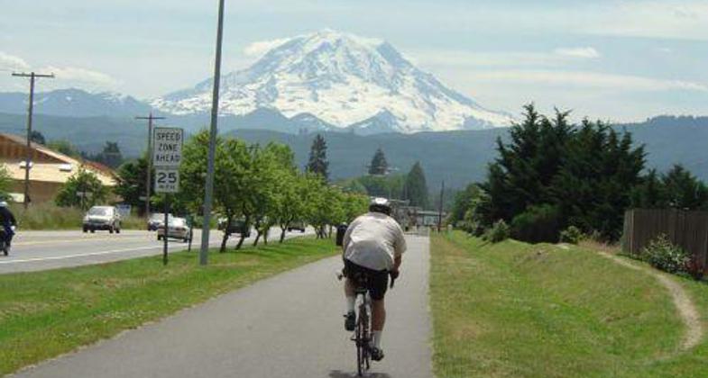
Located in central Pierce County, the 15-mile long Foothills Trail is a 12-foot wide asphalt path with an accompanying 5-foot wide equestrian trail that offers scenic views of South Prairie Creek, Mt. Rainier, and rich fertile farmland. Additionally, the trail system accesses significant environmental areas and connects to local historic and cultural landmarks, parks, schools, and other public facilities.

Foothills Trail - Gateway to National Recreation. Photo by Parks Staff

Equestrian safety patrol.

Historical Burlington Northern railroad marker

Foothills Coalition Safety Patrol
Location: Railtrail constructed on old Burlington Northern Right of Way extending from Puyallup through the city of Orting and into the town of South Prairie.
- States: Washington
- Counties: Pierce
- Cities/Townships: Puyallup, Orting, South Prairie
The Foothills Trail is a 15-mile-long conversion of an abandoned railroad right of way into a paved multi-use recreational public trail for walkers, hikers, bikers, and horseback riders of all skill levels and capabilities. The Foothills Trail is a 12-foot wide porous asphalt path with an accompanying 5-foot wide equestrian trail made of natural materials. and located in a rural wooded scenic environment intermittently bordered by privately owned grazing land and the South Prairie Creek.
Our vision is to provide a safe and separated, non-motorized public trail for multiple kinds of recreational use and as an alternative commuting route between towns and neighborhoods. Located in central Pierce County, the trail system offers five fully-equipped trailheads and accesses significant environmental areas, and connects to local historic and cultural landmarks, parks, schools, and other public facilities.
Additionally, the relatively flat Foothills Trail offers scenic views of South Prairie Creek, Mt. Rainier, rich fertile farmland, and areas where open meadows meet forested hillsides. Coffee stops and eateries are within easy access for people using the trail in the towns of Puyallup, Orting, and South Prairie.
Accessibility Information
No text provided.
Allowed Uses:
Bicycling Dogs, on leash Equestrian Hiking/WalkingOther Activities
- Fishing
- Heritage and history
- Wildlife viewing / observation
Public Contact
Tony TiptonPierce County Parks & Recreation Services
9112 Lakewood Dr SW
Lakewood, WA 98499
[email protected] • 253-798-4250
Contact the trail manager for current maps and visiting details.
More Details
- Elevation (low): 59
- Elevation (high): 431
- Elevation (cumulative): --
- Part of a Trail System? No
- State Designations: WA Audubon Society Birding Trail
- Surface (primary): Paved
- Surfaces (additional): Grass or Vegetation, Rock, crushed
- Tread Width (average): 127"
- Tread Width (minimum): 127
- Running length (minimum): --
- Tread Grade (average, percent): 1
- Tread Grade (maximum): 2
- Running length (maximum): --
- Cross-slope (average, percent): 1
- Cross-slope (maximum): --
- Running length (maximum): --
- Certified as an NRT
May 29, 2012

