Fort Larned Historic Nature Trail
check with the trail manager for updated details before visiting.
Fort Larned Historic Nature Trail
National Park Service
Backcountry Trail
- Length
1.1 miles
- Elevation Gain
--
- Route Type
Loop
- Length
1.1 miles - Elevation Gain
-- - Route Type
Loop
The Fort Larned Nature Trail is a 1-mile loop, half is on a mowed path and half on a gravel park road. The trail highlights nature and history inviting hikers to delve into the past on the Santa Fe Trail.

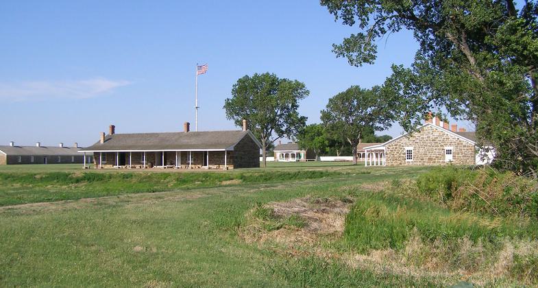
Where Prairie meets Woodlands and River. Photo by William Chapman

The bends and curves on the trail keep hikers in suspense. What is around the bend?
Location: On the grounds of Fort Larned National Historic Site, 1767 KS Hwy 156, Larned, KS 67550. Start is Northeast of the parade ground.
- States: Kansas
- Counties: Pawnee
- Cities/Townships: Pawnee
The Fort Larned Nature Trail is significant to the history of Fort Larned which operated on the Santa Fe Trail from 1859-1878. The sandstone buildings on Fort Larned's quadrangle have survived to today in part because of their sturdy and careful construction. Most frontier military buildings were not of such high quality being built out of weaker materials such as adobe or wood. As hikers and other visitors traverse the Fort Larned Nature Trail, they can imagine the full scale of the living post: a mail station, corrals, stables, stores, and offices amid a stream of countless passing wagons.
The Fort Larned Nature Trail is a one-mile loop, half on a mowed path, and half on a gravel road. There is no significant elevation change along the trail. The entire trail may be completed at a leisurely pace in about half an hour.
The trail begins on the mowed path between the hospital and shop buildings on the northeast corner of the fort. Look for marker #1 to begin the trail. The trail loops around the oxbow of the Pawnee Fork, then along the south side of the fort and behind Officers' Row before returning to the visitor center.
Beyond the fort's walls, the immense prairie that once thrived here was home to bison, wolves, elk, grizzly bears, pronghorns, and more. Most of these animals have been pushed from their homes in the last two centuries as the land has been converted to agriculture, cities, and roads. Fort Larned National Historic Site protects a small area of grassland, offering a window into this now radically altered ecosystem. Today, white-tailed and mule deer are the only ungulates viewed frequently on and near the trail.
The Fort Larned Nature Trail's variety of habitats provides for numerous species of birds such as hawks, orioles, kingbirds, blue jays, and red-headed woodpeckers, among many others. Fort Larned is located on the Central Flyway, a major bird migration corridor. White-fronted geese, sandhill cranes, and many other species pass over Fort Larned during spring and fall migrations.
There are fifteen stops along the trail that are numbered on a 5-foot marker post. These correlate with the FL Nature Trail site bulletin that shares detailed information. The stops are Old Barracks, Cemetery, Oxbow, Quartermaster Stables, Mail Station, Beef Coral, Santa Fe Trail, Native Prairie Grasses, Cavalry Stables, Dugout, Early Officer's Quarters, New Sutler Store, Ice House, and Adjutant's Office.
The Fort Larned Nature Trail is scenic and a great way to get exercise for a daily health regimen. Local visitors who are familiar with the fort's history will use the trail for exercise and the variety of nature it offers. There are opportunities to view the Pawnee River. Although the trail is not tree-lined there are opportunities to find benches slightly on the side of the trail that are in the shade.
Accessibility Information
No text provided.
Allowed Uses:
Dogs, on leash Hiking/WalkingOther Activities
- Heritage and history
- Wildlife viewing / observation
Public Contact
William ChapmanFort Larned National Historic Site
1767 KS Hwy 156
Larned, KS 67550
[email protected] • 620-285-6911
Contact the trail manager for current maps and visiting details.
More Details
- Elevation (low): --
- Elevation (high): --
- Elevation (cumulative): --
- Part of a Trail System? No
- Surface (primary): Grass or Vegetation
- Surfaces (additional): Rock, crushed
- Tread Width (average): 60"
- Tread Width (minimum): 55
- Running length (minimum): --
- Tread Grade (average, percent): --
- Tread Grade (maximum): 1
- Running length (maximum): --
- Cross-slope (average, percent): 1
- Cross-slope (maximum): --
- Running length (maximum): --
- Certified as an NRT
May 16, 2018

