Four C Hiking Trail
check with the trail manager for updated details before visiting.
Four C Hiking Trail
USDA Forest Service
Backcountry Trail
- Length
20 miles
- Elevation Gain
--
- Route Type
out & back
- Length
20 miles - Elevation Gain
-- - Route Type
out & back

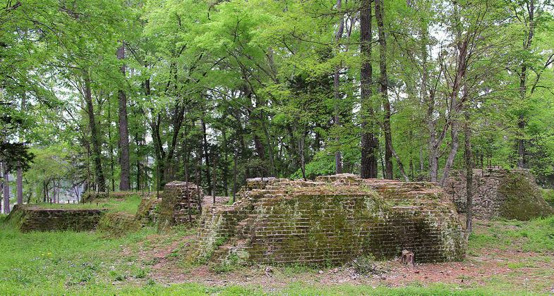
The ruins of the Four C Mill, a former sawmill, in Ratcliff Lake Recreation Area, Houston County, Texas. Photo by Larry D. Moore.

An old bench along an abandoned tramway. Photo by Todd Shelley.

An exceptionally long bridge over wetlands. Photo by Todd Shelley.

Signage at the Walnut Creek Parking Area along FS511. Photo by Todd Shelley.

Walnut Creek shelter is located midway on the trail. Photo by Todd Shelley.

The trail crosses alongside many small ponds. Photo by Todd Shelley.

Pines planted after logging operations. Photo by Todd Shelley.

Mile Marker 10. Photo by Todd Shelley.

Mile Marker 6. Photo by Todd Shelley.

The bridge at Camp Creek has washed away making for a short wade across. Photo by Todd Shelley.
Location: Davy Crockett National Forest
- States: Texas
- Counties: Houston
PLEASE NOTE: A large portion of the trail is now closed due to tornado damage.
Trail Closure Info:
https://www.fs.usda.gov/detail/texas/home/?cid=fseprd624937
https://www.fs.usda.gov/detail/texas/news-events/?cid=FSEPRD622929
The trail not only passes through several distinct vegetation communities, but the entire landscape surrounding the trail is a vast cultural resource. The 4-C NRT is named for the Central Coal & Coke Company, which logged virgin timber from the region in the early 1920s. The Civilian Conservation Corps planted the trees that are now the forest surrounding the trail.
The southern trailhead for the trail is at Ratcliff Lake Recreation Area. Ratcliff Lake was the log pond for the sawmill operations of the Central Coal & Coke Company. Much of the 4-C NRT travels along abandoned railroad tramways once used to transport lumber.
The 4-C NRT passes through pine stands, bottomland hardwoods, sloughs, and upland forests, as well as the 3,900-acre Big Slough Wilderness Area, one of only five National Wilderness Areas in East Texas. The first _-mile of the 4-C NRT has been developed to be wheelchair accessible.
At twenty miles, the 4-C NRT offers visitors hiking experiences in a diversity of environments and lends itself well to hiking either in sections, as a one-way, 20-mile (two-day) trip or a two-way, 40-mile (four-day) backpacking trip. The 4-C NRT is one of only a handful of trails in East Texas of substantial length, greater than 3-4 miles.
Accessibility Information
No text provided.
Allowed Uses:
Dogs, on leash Hiking/WalkingOther Activities
- Camping
- Fishing
- Wildlife viewing / observation
Public Contact
Merlinda SchoryDavy Crockett National Forest
Route 1, Box 55FS
Kennard, TX 75847
[email protected] • (936) 655-2299
Contact the trail manager for current maps and visiting details.
More Details
- Elevation (low): 185
- Elevation (high): 697
- Elevation (cumulative): --
- Part of a Trail System? No
- Surface (primary): Soil
- Surfaces (additional): Soil
- Tread Width (average): 36"
- Tread Width (minimum): --
- Running length (minimum): --
- Tread Grade (average, percent): --
- Tread Grade (maximum): 58
- Running length (maximum): --
- Cross-slope (average, percent): --
- Cross-slope (maximum): --
- Running length (maximum): --
- Certified as an NRT
Jun 28, 1979

