Garnet Mountain Trail
check with the trail manager for updated details before visiting.
Garnet Mountain Trail
USDA Forest Service
Backcountry Trail
- Length
3.4 miles
- Elevation Gain
--
- Route Type
out & back
- Length
3.4 miles - Elevation Gain
-- - Route Type
out & back
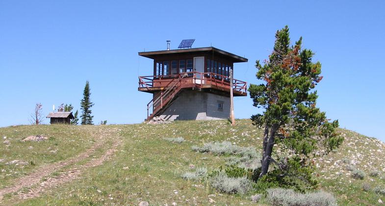
Strenuous day hike to the top of Garnet Mountain with old fire lookout, now used as a recreational cabin.
Location: Just north of Big Sky, MT., In Gallatin National Forest, 25 mi. S of Bozeman on Squaw Creek Road 2 mi. off US 191.
- States: Montana
- Counties: Gallatin
This hike has two routes. One follows an old double-track logging road, climbing steadily until the very end. The other is a steep singletrack that ties into the logging road about a half-mile below the peak. The singletrack trail is 3.5 miles to the top, gaining 2,800 feet of elevation along the way. The double-track trail winds around the back side of the mountain, passing Rat Lake, a few ponds, and the turnoff to Pioneer Lakes along its 4-mile length. Both routes offer great views. The canyon's forested slopes and distant peaks make for epic scenery. Near the summit, the trail passes through a livestock fence and climbs to a fire lookout tower atop the mountain. The tower was built in 1930 and is available to rent for camping through the Montana Recreation Rental Program. Carry bear spray.
Accessibility Information
No text provided.
Allowed Uses:
Dogs, on leash Equestrian Hiking/WalkingPublic Contact
Brian McNeil3710 Fallon Street, Suite C
Bozeman, MT 59718
[email protected] • (406) 522-2520
www.fs.fed.us/r1/gallatin
Contact the trail manager for current maps and visiting details.
More Details
- Elevation (low): 5600
- Elevation (high): 8300
- Elevation (cumulative): --
- Part of a Trail System? No
- Surface (primary): Soil
- Surfaces (additional): Soil
- Tread Width (average): 24"
- Tread Width (minimum): --
- Running length (minimum): --
- Tread Grade (average, percent): 15
- Tread Grade (maximum): 30
- Running length (maximum): --
- Cross-slope (average, percent): --
- Cross-slope (maximum): --
- Running length (maximum): --
- Certified as an NRT
Oct 18, 1979


