General Dacey Trail
check with the trail manager for updated details before visiting.
General Dacey Trail
U.S. Corps of Engineers
Backcountry Trail
Frontcountry Trail
Urban Trail
- Length
4 miles
- Elevation Gain
--
- Route Type
Loop
- Length
4 miles - Elevation Gain
-- - Route Type
Loop
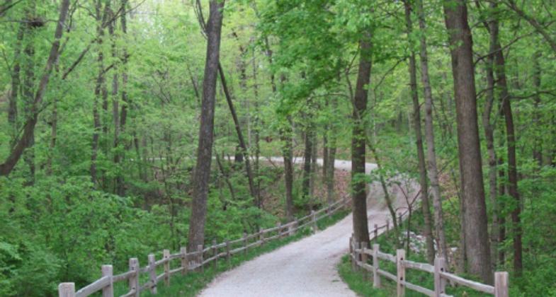
The General Dacey Trail is a multipurpose trail designed for walkers, runners, and bicyclists. This trail is a great place for the whole family to spend time together enjoying the outdoors. Besides exercising, the trail is a great place for bird-watching, geo-caching, and photography. The trail offers users many opportunities to pause on donated benches and contemplate stunning views of Lake Shelbyville and the area.
Location: Multi-Purpose Trail that connects Lake Shelbyville and Forrest Park in Shelbyville, IL
- States: Illinois
- Counties: Shelby
- Cities/Townships: Shelbyville
The General Dacey is a multi-purpose trail system consolidating the City of Shelbyville, Shelbyville's Forest Park, and Lake Shelbyville, which is a U.S. Army Corps of Engineers project. Designed for walkers, runners, and bicyclists the trail has developed and expanded over the past 10 years and is now a premiere attraction for physical fitness, family gatherings, educational opportunities, wildlife habitat, and one of the leading tourist attractions in the area.
The trail centered around Lake Shelbyville benefits thousands of citizens for bicycling, hiking, running, and other recreational uses, all while serving as a hub for community events and activities. The trail committee has creatively forged partners and planned multiple fundraisers for charitable organizations & school groups, support for victims of domestic/sexual violence, local cross-country sporting events, and health awareness events, and created an amazing winter hike that has drawn visitors to the area and Lake Shelbyville at a time not typically utilized as a recreational season.
The trail journeys along one of the most scenic and highly visited areas of the lake and has developed into one of the area's best and most used attractions. The trail has significantly integrated a connection between the community of Shelbyville, Shelbyville's Forest Park, and Federal lands; including Dam West, Dam East, and Spillway Recreation Areas, as well as the Lake Shelbyville Visitor Center. The connection between these areas has intermeshed users of the trail and exposed them to different areas of the community. The placement of personal fitness equipment stations within the Dam West Overlook area has resulted in additional awareness of Lake Shelbyville for trail users. This equipment is suited for all ages and brings a very diverse group of users to the area.
An interpretive trail hike has become one of the most requested programs from school groups visiting Lake Shelbyville. These interpretive hikes provide all participants with a hands-on interactive experience to learn about invasive species, wildlife enhancement practices, and erosion control and allow them an opportunity to enter into an environment that they may otherwise not have had the opportunity to experience. The trail was designed with greenways to promote natural wildlife sustainability. The trail also serves as a corridor for Lake Shelbyville Park Rangers to conduct tours of the dam. Allowing for accessibility, safety, and an educational platform, the trail has been incorporated into all tours of the dam, providing a well-rounded educational experience as well as a physical experience.
The trail has also benefited agencies such as the Boy Scouts of America to provide a quality location for scouting activities and programs. The scouts have taken on projects, such as clearing paths, trail maintenance, public event assistance, and individual merit projects. The committee has supported individual scouts with projects, including Eagle Scout achievements.
The trail provides locals with a single location for a diverse species of tree identification and education. Currently, the original phase of the trail has a variety of trees identified and marked with unique plaques, providing local students and visiting public with information about local trees. In November 2012, an additional 18 interpretive signs will be added to the northern loops of the trail.
Undoubtedly the success of the General Dacey Trail would not have been accomplished without the assistance from the surrounding community and volunteers. The pride and ownership the community has developed toward this trail has strengthened relationships, developed friendships, and encouraged and promoted other community involvement and activities. Since ground was first broken on Phase I of the trail, volunteers have dedicated thousands of hours of hard work and dedication to the expansion and care of the trail system. Additionally, community organizations have partnered and joined forces to enhance and develop the trail.
The trail has drawn in several partners engaging all aspects of the community. The committee has partnered with the local high school and jr. high cross country teams, serving as host to all home meets, and also selected as host for sectionals and invitationals. As previously mentioned, the Boy Scouts of America have also partnered and benefited from the multiple benefits that the General Dacey Trail has to offer. Over the years the General Dacey Trail has forged` over two dozen partners, which not only benefited the trail system, but also resulted in many new partnerships formed between different organizations for other community events and projects, thus making the General Dacey Trail one of the largest catalyst for developing community relationships between volunteers, contributors, and partnering organizations.
Serving a very diverse group of individuals has been and remains one of the top functions of the trail, including 100% accessible trail sections that are American with Disabilities Act compliant, resulting in a family-friendly environment accessible by strollers and wheelchairs. All ages are welcome on the General Dacey Trail.
Accessibility Information
No text provided.
Allowed Uses:
Bicycling Swimming Dogs, on leash Hiking/Walking Motorized vehicles, snowmobiling Snow, cross-country skiingOther Activities
- Fishing
- Hunting
- Snow, snow play general
- Wildlife viewing / observation
Public Contact
Phillip ManhartU.S. Army Corps of Engineers
R.R. 4 Box 128B
Shelbyville, IL 62565
[email protected] • (217) 774-3951
Contact the trail manager for current maps and visiting details.
More Details
- Elevation (low): 556
- Elevation (high): 640
- Elevation (cumulative): --
- Part of a Trail System? No
- Surface (primary): Rock, crushed
- Surfaces (additional): Paved
- Tread Width (average): 120"
- Tread Width (minimum): 120
- Running length (minimum): --
- Tread Grade (average, percent): 1
- Tread Grade (maximum): 5
- Running length (maximum): --
- Cross-slope (average, percent): 1
- Cross-slope (maximum): --
- Running length (maximum): --
- Certified as an NRT
May 29, 2013


