Grayson Lake Nature Trail
check with the trail manager for updated details before visiting.
Grayson Lake Nature Trail
U.S. Corps of Engineers
Backcountry Trail
- Length
1.8 miles
- Elevation Gain
--
- Route Type
Loop
- Length
1.8 miles - Elevation Gain
-- - Route Type
Loop
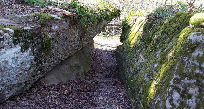
The one-mile National Registered Nature Trail follows the Little Sandy River through ravine, mature woodland, and open areas of various stages of succession.
Location: 7 miles southwest of Grayson at Grayson Lake Dam.
- States: Kentucky
The trail passes through hemlock, sandstone cliffs, and rock formations that create picturesque waterfalls in wet seasons. In spring, the trail is beautifully adorned with many wildflowers, dogwood, and redbuds trees, especially in June when the mountain laurel is blooming. Wildlife is abundant and can be enjoyed at the many resting areas along the trail.
From the Nature Trail, those wanting a longer walk; can connect with the 2-mile Primitive Loop Trail. This trail will take you up the hill, across the ridge, and down to the Environmental Study Area. Along the trail be sure to listen for the sounds of worm-eating warblers and the musical song of the scarlet tanager. Other species include yellow-billed cuckoo, summer tanager, and indigo bunting. Be on the lookout for one of the six species of woodpeckers that live in the area, as well as turkey and grouse.
The Environmental Study Area is accessible for those with limited walking abilities and wheelchairs. You will find tall native grasses full of butterflies, sparrows, and other grass-loving birds. Check out the wetlands for turtles, frogs, and others using the wetland. Food plots make viewing deer an easy task.
Accessibility Information
No text provided.
Allowed Uses:
Swimming Dogs, on leash Hiking/WalkingOther Activities
- Camping
- Fishing
- Wildlife viewing / observation
Public Contact
Frank JeffreyUS Army Corps of Engineers
COE, 50 Launch Ramp Rd.
Grayson, KY 41143
(606) 474-5815
Contact the trail manager for current maps and visiting details.
More Details
- Elevation (low): --
- Elevation (high): --
- Elevation (cumulative): --
- Part of a Trail System? No
- Surface (primary): --
- Surfaces (additional): --
- Tread Width (average): 36"
- Tread Width (minimum): --
- Running length (minimum): --
- Tread Grade (average, percent): --
- Tread Grade (maximum):
- Running length (maximum): --
- Cross-slope (average, percent): --
- Cross-slope (maximum): --
- Running length (maximum): --
- Certified as an NRT
Aug 13, 1978


