Greenbrier River Trail
check with the trail manager for updated details before visiting.
Greenbrier River Trail
State
Rail Trail
- Length
78 miles
- Elevation Gain
--
- Route Type
out & back
(1 review)
- Length
78 miles - Elevation Gain
-- - Route Type
out & back
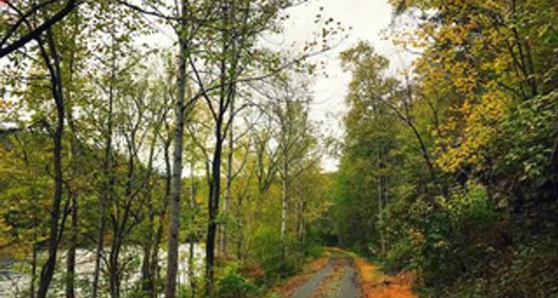
The Greenbrier River Trail is a 78-mile former railroad now used for hiking, biking, and horseback riding. It is the longest trail of its kind in West Virginia. The trail provides many breathtaking views as it passes through several small towns, crosses 35 bridges, goes through two tunnels, and cuts through some of West Virginia's most remote areas. Part of the Greenbrier River Trail lies within a National Radio Quiet Zone so cell phones do not work.
Location: The Greenbrier River Trail runs 78 miles parallel to the Greenbrier River in both Greenbrier and Pocahontas counties, West Virginia. It begins in the town of Caldwell, WV between White Sulphur Springs and Lewisburg, WV and runs north to Cass, WV to the Ca
- States: West Virginia
- Counties: Greenbrier, Pocahontas
- Cities/Townships: Caldwell, Renick, Marlinton, Cass
West Virginia's beautiful Greenbrier River Trail is one of America's premier rail trails and is popular with bicyclists, hikers, walkers, and cross-country skiers. Most of the trail runs along the gorgeous Greenbrier River and passes through picturesque countryside as it winds through the river valley.
Today, the trail is operated and maintained by West Virginia State Parks, but it was originally built for use by one of the many West Virginia railroads that served the once-prospering local timber industry. Now the trail is for recreational use, with overnight campsites and many restrooms and water facilities scattered along its route. The trail hosts the popular annual Great Greenbrier River Race: canoeing, biking, and running.
Even though the mileposts start at the southern end of the Greenbrier River Trail, many choose to start the trip on the slightly uphill grade at the northern end at Cass Scenic Railroad State Park and follow the river downstream.
In its 78-mile length, the rail trail contains many of the elements that make the Mountain State one of America's favorite retreats: the peaks and valleys, the lush forests, the pioneering history, the genuine hospitality of its small towns, and, of course, the river. Sometimes silent and lazy, in other seasons full and ambitious, the Greenbrier River is an almost constant companion to the trail and flavors the journey at every step.
The Trail brings visitors into the precious wild environment of West Virginia. The towns along its route have been sustained by the Trail, but not compromised. This balance is evident in wild stretches along the pathway and in the communities that connect to it.
Trains ran here around the turn of the 20th century. Construction began on what would become the Greenbrier Division of the Chesapeake and Ohio Railway (C&O) in 1899, and for the next 77 years, trains hugging the river carried lumber and passengers beyond the valley and through eastern West Virginia.
When the line became unprofitable in the 1970s, the last remaining depots closed their doors. But when C&O donated the corridor to the state, a new opportunity emerged. Realizing the tremendous resource before them, local communities mobilized a force of trail supporters and volunteers behind the effort, and three decades later the Greenbrier River Trail is one of the most famous and well-loved rail-trails in America and an object of tremendous pride among the communities that built it.
Heading south on the Greenbrier River Trail, the first town you will pass is Clover Lick, a lovely little Appalachian town with rustic remnants of the old railroad depot that once served the booming logging industry.
Beyond the Clover Lick trailhead, the trail proceeds south, winding 20 miles downstream through some of the most scenic and remote wilderness landscapes in West Virginia. Just south of Clover Lick is Sharps Tunnel, 511 feet long and built in 1899 opening to a 230 feet curved bridge, known by some as the Greenbrier River Bridge, one of the more memorable features of the trail.
Next is the only large town you will encounter along the trail, Marlinton, which hosts some great lunch spots and B&Bs. You can find a trailside information center in Marlinton's old train station near mile 55. As you proceed south from Marlinton, you will cross the river twice before reaching the halfway point at Beard.
One of the great things about the Greenbrier River Trail is the opportunity to see remnants of the old railroad, including many whistle-stops and historical mile markers. Beyond Beard (milepost 31) is the second of the trail's two spectacular tunnels: the 402-foot-long Droop Mountain Tunnel, built in 1900.
Continuing south, beyond Anthony (at mile 15), the trail crosses two old railroad bridges and eventually reaches its southern terminus at North Caldwell (milepost 3). This trailhead is located just outside the charming town of Lewisburg.
The river and the trail are surrounded by forest and the occasional clearing; hemlock, red spruce, oak, pine, honeysuckle, azalea, and even the occasional balsam fir, rarely seen this far south.
One of the best features of the Greenbrier River Trail is that it has achieved accessibility without compromising its remote character. A number of small shelters and fire rings along the trail provide hospitality for trail users, yet these amenities feel more like genuine relics of the
pioneering days than intruding modern amenities. The old-fashioned water pumps and restored depot buildings along the way contribute to this vibe.
Most trailheads pop out into tiny communities of well-kept colonial-style homes, among lovely valleys and far from any sounds but the river. Though the northern reaches of the trail are a little wilder and more isolated than the southern, the difference is not marked, and any stretch of this wonderful trail has a wilderness feel.
Accessibility Information
No text provided.
Reviews
James Kaser
A Great Ride!
I heard about your trail from the Rails to Trails Hall of Frame. So my wife and I made the trip from Toledo Ohio to have a day ride on the Greenbrier River Trail. Our ride started in Cass and finished in Caldwell. Along the way we stopped and had lunch at Alfredo's which was delicious. From your group I learned about the Greenbrier River Shuttle. Amelia was super to work with. She picked up our car in Cass and had it waiting for us in Caldwell. We rode this past Friday, April 15, 2022 and the weather was gorgeous! Low 30's at the beginning to low 70's at the end and sunshine! Thank you for sharing your marvelous trail with us!
Allowed Uses:
Bicycling Swimming Dogs, on leash Equestrian Hiking/Walking Snow, cross-country skiingOther Activities
- Camping
- Fishing
- Heritage and history
- Snow, snow play general
- Wildlife viewing / observation
Public Contact
Jody SpencerWest Virginia Division of Natural Resources
4800 Watoga Park Road
Marlinton, WV 24954
[email protected] • (304) 799-4087
Contact the trail manager for current maps and visiting details.
More Details
- Elevation (low): 1696
- Elevation (high): 2688
- Elevation (cumulative): --
- Part of a Trail System? No
- National Designations: 50 Millennium Legacy Trail, Rails to Trails Conservancy Trail of the Month June 2012, Backpacker magazine's Top 10 Hiking Trai
- Surface (primary): Rock, crushed
- Surfaces (additional): Paved, Rock, crushed
- Tread Width (average): 120"
- Tread Width (minimum): 0
- Running length (minimum): --
- Tread Grade (average, percent): 1
- Tread Grade (maximum):
- Running length (maximum): --
- Cross-slope (average, percent): 0
- Cross-slope (maximum): --
- Running length (maximum): --
- Certified as an NRT
Jun 3, 2021