Gunlogson Nature Preserve
This information is a public record of the 1978 NRT application and may be out of date if it has not been updated by a trail manager --
check with the trail manager for updated details before visiting.
check with the trail manager for updated details before visiting.
Gunlogson Nature Preserve
State
Backcountry Trail
- Length
0.75 miles
- Elevation Gain
--
- Route Type
out & back
(1 review)
- Length
0.75 miles - Elevation Gain
-- - Route Type
out & back

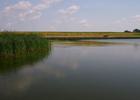
Renwick Dam creating Lake Renwick, Icelandic State Park, North Dakota. Photo by McGhiever.

Gunlogson Farmstead Historic Site, Icelandic State Park, North Dakota. Photo by McGhiever.
Location: Rural - west of Cavalier, ND
- States: North Dakota
- Counties: Pembina
Located in Gunlogsen Nature Preserve, ND's first Nature Preserve. Across its 94-acre expanse are found three state rare species of bird, rare fish, and plans in a premier woodland/wetland community. Trail guide and education information posts explain.
Accessibility Information
No text provided.
Reviews
Wendy Schmeichel
Nice easy stroll
This is a nice easy stroll. It is a self guided nature trail. There are additional trails that you can enjoy if you want a longer walk.
Allowed Uses:
Swimming Hiking/WalkingOther Activities
- Camping
- Wildlife viewing / observation
Public Contact
Henry DurayNorth Dakota Parks and Recreation
Icelandic State Park
Cavalier, ND 58220
[email protected] • (701) 265-4561
Contact the trail manager for current maps and visiting details.
More Details
- Elevation (low): 942
- Elevation (high): 987
- Elevation (cumulative): --
- Part of a Trail System? No
- Surface (primary): Soil
- Surfaces (additional): --
- Tread Width (average): 60"
- Tread Width (minimum): --
- Running length (minimum): --
- Tread Grade (average, percent): --
- Tread Grade (maximum):
- Running length (maximum): --
- Cross-slope (average, percent): --
- Cross-slope (maximum): --
- Running length (maximum): --
- Certified as an NRT
Jul 13, 1978