Hatfield-McCoy Trails
check with the trail manager for updated details before visiting.
Hatfield-McCoy Trails
Commission
Backcountry Trail
- Length
500 miles
- Elevation Gain
--
- Route Type
out & back
- Length
500 miles - Elevation Gain
-- - Route Type
out & back
Location: Southern West Virginia
- States: West Virginia
- Counties: Logan, Mingo, Boone, Wyoming
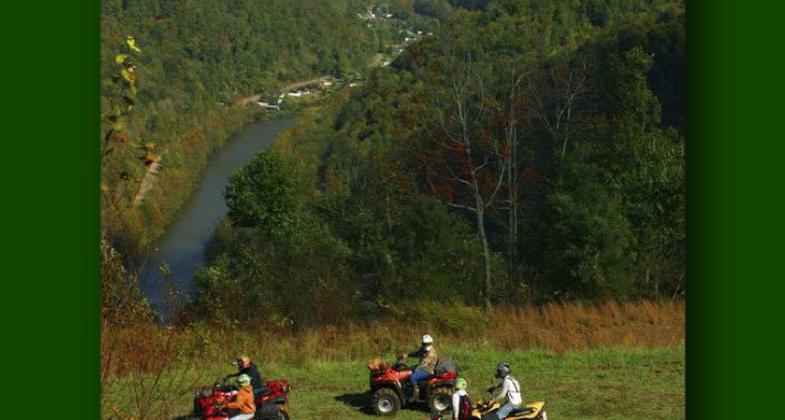
Hatfield-McCoy Regional Recreation Area, better known as the Hatfield-McCoy Trails, is a professionally designed trail system that provides a safe recreational experience for all-terrain vehicles, off-highway motorcycles, mountain bikers, hikers, and equestrian users. The first 300 miles opened to the public in October 2000. Currently, there are 500 miles of trails with expansion plans continuing until the trails reach a network of 2,000 miles with continuous trails weaving throughout eight counties in Southern West Virginia (Boone, Lincoln, Logan, McDowell, Mercer, Mingo, Wayne, and Wyoming) on private and corporate-owned property.
The trails have sold over 23,000 permits since opening and have had visitors from forty-six states and six countries. Survey data indicates that 57.3% of visitors are very likely to return and feel their visit was, Great- worth the trip, and 34.8% indicate the trails are Awesome- the best place ever ridden.
The intention of the trail system is to provide the finest recreational trail experience in the country. The trail system compliments the natural beauty of the Appalachian Mountains and is one that cooperating landowners, area residents, and businesses are proud to host. The trail system has sparked an entrepreneurial spirit throughout southern West Virginia. Many new businesses have been generated and old businesses on the verge of closing; have now been rejuvenated.
The Hatfield-McCoy Trail System is designed on privately owned property. Each trail within the system is numbered and rated according to difficulty (Green = Easiest, Blue= More Difficult, Black = Most Difficult, and Orange = Single Track). The BLM provides oversight on construction, maintenance, and environmental issues. The trail systems currently connect to the Town of Matewan and the Town of Gilbert. This allows trail riders to enter towns for lodging, food, water, etc.
The Hatfield-McCoy Trail system interacts with many historical towns, monuments, museums, and other tourist attractions such as the Matewan Massacre, Twisted Gun Golf Course, Shawnee Living History Trail, Coal Heritage Trail, Chief Logan Civil War and Indian Museum, and Hatfield Cemetery, where the famous"Devil Anse Hatfield" statue is located. Each town has its own unique history and places to visit. The Hatfield-McCoy Regional Recreation Authority not only draws interest to the trail system: once visitors are here, they are anxious to learn the history that surrounds southern West Virginia.
The cost of a 1-day permit is $15, a 7-day permit is $35, West Virginia residents pay $25 per year and out-of-state residents pay $100 per year.
The Hatfield-McCoy Trail System has been featured in many popular sports-oriented magazines such as Dirt Wheels, ATV Action, ATV Sport, REV Magazine, and ATV Magazine. ATV Magazine TV aired a 6-minute segment on the trails on Outdoor Life Network and The Discovery Channel. The Hatfield-McCoy Trails website (www.trailsheaven.com) received 2.3 million visits during the month of June 2003.
Finally, the Coalition for Recreational Trails recently awarded the Hatfield-McCoy Trail System the "2003 Achievement Award" for Outstanding Use of Recreational Trails Program Funds in the category of Construction and Design - Long Distance.
Accessibility Information
No text provided.
Allowed Uses:
Bicycling Dogs, on leash Equestrian Hiking/Walking Motorized vehicles, – ATV/ORV Motorized vehicles, motorcyclingPublic Contact
Matthew G. BallardHatfield-McCoy Regoinal Recreation Authority
P.O. Box 539
Lyburn, WV 25632
[email protected] • (304) 752-3255
www.trailsheaven.com
Contact the trail manager for current maps and visiting details.
More Details
- Elevation (low): 800
- Elevation (high): 2600
- Elevation (cumulative): --
- Part of a Trail System? No
- National Designations: National Millenium
- Surface (primary): Rock, crushed
- Surfaces (additional): Soil
- Tread Width (average): 127"
- Tread Width (minimum): --
- Running length (minimum): --
- Tread Grade (average, percent): 127
- Tread Grade (maximum): 40
- Running length (maximum): --
- Cross-slope (average, percent): --
- Cross-slope (maximum): --
- Running length (maximum): --
- Certified as an NRT
Jun 1, 2004


