Hell's Bay Canoe
check with the trail manager for updated details before visiting.
Hell's Bay Canoe
National Park Service
Water Trail (other)
- Length
8 miles
- Elevation Gain
--
- Route Type
out & back
- Length
8 miles - Elevation Gain
-- - Route Type
out & back
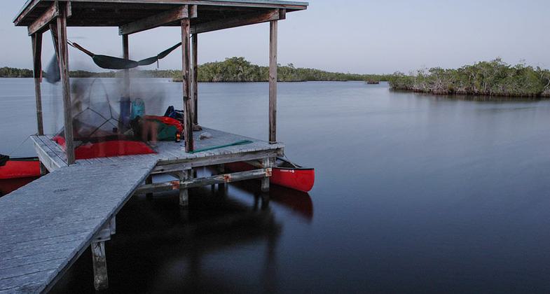
Camping chickee in Hell's Bay, Everglades National Park, Florida. Photo by Tristan Loper.
Location: In Everglades National Park, connects park road to Hell's Bay. (recertified 1992)
- States: Florida
The Hell's Bay Canoe Trail runs through a complex mangrove ecosystem in the Everglades. So named because it was once considered "hell to get into, hell to get out of," the trail takes paddlers through several small ponds and bays. The trail is marked with more than 160 poles.
It also passes two backcountry chickees and a ground site; camping is allowed with a backcountry permit. It takes approximately six to eight hours to explore the entire trail, which runs 5.5 miles one way.
Before embarking, check with the park's visitor's center about trail conditions since dry conditions could affect access. The dry season is usually from February to May.
Accessibility Information
No text provided.
Allowed Uses:
Boating, human-poweredPublic Contact
Everglades National ParkP.O. Box 279
Homestead, FL 33030
More Details
- Elevation (low): --
- Elevation (high): --
- Elevation (cumulative): --
- Part of a Trail System? No
- Surface (primary): --
- Surfaces (additional): --
- Tread Width (average): 0"
- Tread Width (minimum): --
- Running length (minimum): --
- Tread Grade (average, percent): --
- Tread Grade (maximum):
- Running length (maximum): --
- Cross-slope (average, percent): --
- Cross-slope (maximum): --
- Running length (maximum): --
- Certified as an NRT
Mar 19, 1981