Highline Trail
check with the trail manager for updated details before visiting.
Highline Trail
USDA Forest Service
Backcountry Trail
- Length
45 miles
- Elevation Gain
--
- Route Type
out & back
- Length
45 miles - Elevation Gain
-- - Route Type
out & back
Steep, rocky terrain along the Mogollon Rim with spectacular views, canyons, and brushy hills. Established in 1870, Zane Grey used the trail while hunting in the area. Travel route between homesteads and schools.
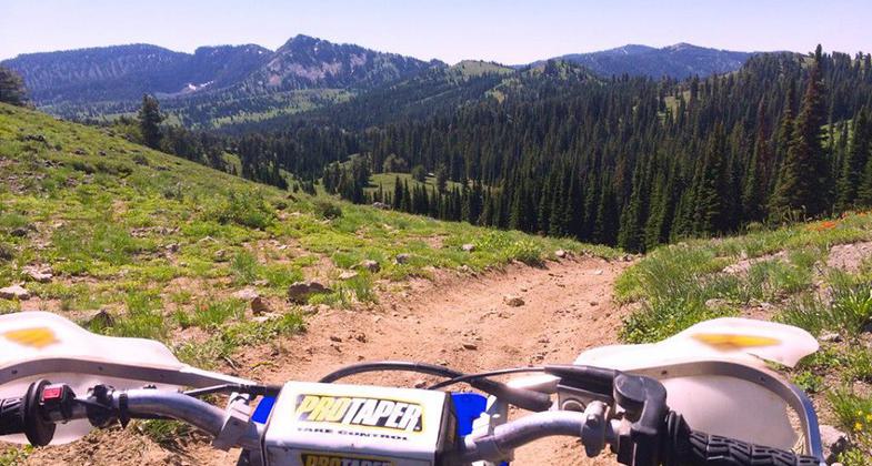
Location: Backcountry/Wilderness, Wasatch Range.
- States: Idaho
- Counties: Bear Lake
The Idaho section of the Highline Trail originates at the northernmost end of the Wasatch Mountain Range. The trail runs south along the spine of the range for 45 miles to the Idaho-Utah border. Throughout the length of the Highline Trail, the visitor is greeted with scenic vistas of the Gem, Bear Lake, and Cache Valleys. This Trail is the premier trail of all the trails in the Montpelier District. Andrew Romero, a ranger who built the Eight-Mile Ranger Station, worked on the trail in 1907.
Romero contends that the northern end of the trail followed the Indian route of the time. There are several trails that intersect with the Highline Trail, including the Shoshone Indian Trail, which was the mail route for the early settlers of the Cache and Bear Lake Valleys.
The Highline Trail is the longest trail in the entire Caribou/Cache National Forest, going from Soda Point in the north to Beaver Creek to the south. Elevations on the trail run from 6,400 feet in Egan Basin to 8,921 feet at Soda Peak. Several points of interest are encountered on the trail. The visitor has access to Soda Point, Soda Peak, The German Dugway, and Bloomington Lake and should not leave the area without visiting Minnetonka Cave.
The most popular access to the Highline Trail would be the trailhead in Emigration Canyon. Drive west from Montpelier, Idaho on Hwy. 89 to Ovid, Idaho, 6 miles. Veer right at the Junction of 89 and Hwy. 36. Follow Hwy. 36 for 12.5 miles. Turn left onto Copenhagen Basin Road. The trailhead parking lot is approximately 200'.
Accessibility Information
No text provided.
Allowed Uses:
Bicycling Swimming Dogs, on leash Equestrian Hiking/Walking Snow, cross-country skiing Snow, snowshoeingOther Activities
- Camping
- Snow, snow play general
Public Contact
Maury YoungCaribou National Forest
Montpelier Ranger District
Montpelier, ID 83254
(208) 847-0375
Contact the trail manager for current maps and visiting details.
More Details
- Elevation (low): --
- Elevation (high): --
- Elevation (cumulative): --
- Part of a Trail System? No
- Surface (primary): Soil
- Surfaces (additional): --
- Tread Width (average): 42"
- Tread Width (minimum): --
- Running length (minimum): --
- Tread Grade (average, percent): --
- Tread Grade (maximum):
- Running length (maximum): --
- Cross-slope (average, percent): --
- Cross-slope (maximum): --
- Running length (maximum): --
- Certified as an NRT
May 7, 1979