Historic Champlain Canalway Trail
check with the trail manager for updated details before visiting.
Historic Champlain Canalway Trail
City, Town, or County
Frontcountry Trail
- Length
6 miles
- Elevation Gain
--
- Route Type
out & back
(1 review)
- Length
6 miles - Elevation Gain
-- - Route Type
out & back
An approximately 6-mile segment of the projected 58-mile long Canalway Trail corridor, this trail in Halfmoon appeals to bird watchers, history buffs, and health-conscious recreationists.

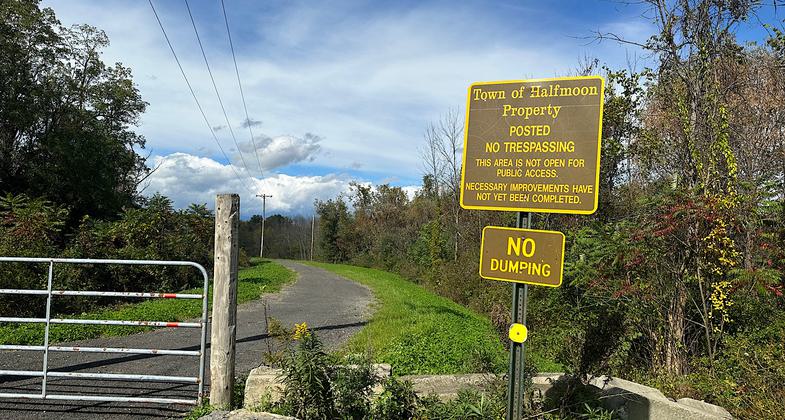
Oct 2023 sign showing closure of southern bit. Photo by Janie Walker


Photo by Connie Golden.

Photo by Kim Martin.

The 1823 Lock is well preserved and water tight 175 years later. Photo by Kim Martin.

Photo by Connie Golden.

Location: Follows canal from S of Mechanicsville through Halfmoon to the Waterford Town line north of Schoolhouse Lane.
- States: New York
- Counties: Saratoga
The Historic Champlain Canalway Trail in the Town of Halfmoon is approximately a six-mile segment of a 58-mile-long Canalway Trail corridor. The Town of Halfmoon participates in an ongoing planning effort coordinated by the NPS Rivers, Trails and Conservation Assistance Program with the goal, "To complete and promote an attractive and continuous route for the Champlain Canalway Trail from Waterford to Whitehall, including historic towpaths, community attractions, and parallel on-street bicycle routes."
The Town of Halfmoon owns the Champlain Canalway Trail corridor within the Town. Approximately three miles of the trail is an improved, stone dust trail that is eight feet wide. Trailhead parking is available at the northern end of the improved trail segment and an additional trailhead parking lot is located off Brookwood Road. To the north of the improved segment are segments of unimproved trail. These segments are essentially footpaths at this time. The Town has plans and grant applications pending to construct, multi-use stone dust trail segments for the entire six miles of trail within Halfmoon. The six miles of trail are located in a rural setting, with the trail bordered by farm fields, wetlands, and wood lots.
Accessibility Information
No text provided.
Reviews
Janie Walker
neighborhood bike/walking path along canal
Oct 9, 2023. This NRT is supposed to be six miles long, but at this time (Oct 2023) the northernmost three miles are closed to the public. This is a gravel path following Old Champlain Canal through Halfmoon. Fairly basic and flat with enjoyable water views most of the way. There were a ton of woolly bear caterpillars crossing the path all along the route when I was there. Lots of brown showing, so if you believe the folklore, this means a mild 2023-2024 winter for the Albany/Mechanicville region.
Allowed Uses:
Dogs, on leash Hiking/WalkingPublic Contact
Carrie Milano2 Halfmoon Town Plaza
Halfmoon, NY 12065
[email protected] • (518) 371-7410 ext. 2206
www.townofhalfmoon.org
Contact the trail manager for current maps and visiting details.
More Details
- Elevation (low): 243
- Elevation (high): 276
- Elevation (cumulative): --
- Part of a Trail System? No
- Surface (primary): Rock, crushed
- Surfaces (additional): Rock, crushed
- Tread Width (average): 96"
- Tread Width (minimum): --
- Running length (minimum): --
- Tread Grade (average, percent): --
- Tread Grade (maximum):
- Running length (maximum): --
- Cross-slope (average, percent): --
- Cross-slope (maximum): --
- Running length (maximum): --
- Certified as an NRT
May 25, 2009

