Illinois Prairie Path
check with the trail manager for updated details before visiting.
Illinois Prairie Path
City, Town, or County
Rail Trail
- Length
27.8 miles
- Elevation Gain
--
- Route Type
out & back
- Length
27.8 miles - Elevation Gain
-- - Route Type
out & back
The Illinois Prairie Path is a 61-mike hiking/biking trail located about 20 miles west of Chicago, Illinois, in Cook, DuPage and Kane Counties.

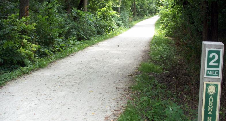
2-mile marker of the Aurora Branch of the Illinois Prairie Path. Photo by Tomjackson/wiki.

Clouds above the trestle approach. Photo by Jonathan Voelz.

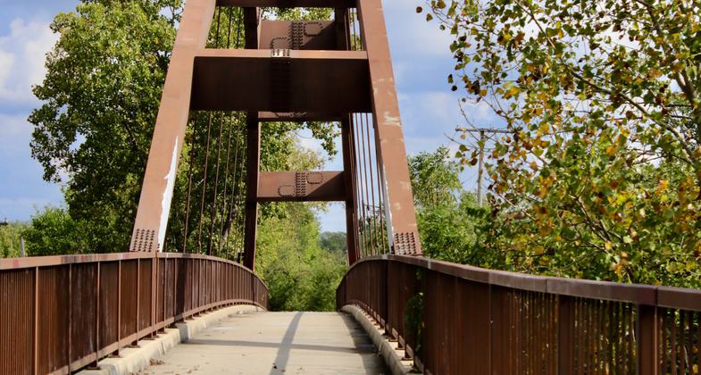
Pedestrian truss bridge for the Illinois Prairie Path. Photo by Lpangelrob/wiki.
Location: Three-branched system joining Aurora, Elgin, and Oak Park, with junction in Wheaton.
- States: Illinois
- Counties: DuPage, Kane, Cook
In 1963 a small group of trail enthusiasts, led by noted naturalist May Theilgaard Watts, determined to develop a nature path through the western suburbs of Chicago. In 1965 they formed The Illinois Prairie Path, a not-for-profit corporation made up of volunteers; and in 1966 after much work, they leased the old Chicago, Aurora, and Elgin (CA&E) Railroad right-of-way from the new owner, DuPage County, and began building the trail. The first green-and-white logo signs went up in 1967, and The Path was officially on the map. In 1971 most of the Illinois Prairie Path was designated a National Recreation Trail, part of the National Trails System.
Many governmental agencies have played a major role in Path development. In 1972 the State of Illinois Department of Conservation acquired much of the CA&E right-of-way in Kane County. This land was leased to the Kane County Forest Preserve District and to the Fox Valley Park District so that the Prairie Path could be extended to the Fox River at Elgin, Batavia, and Aurora. In 1979 the Illinois Department of Conservation purchased 4.5 miles of the right-of-way in Cook County to extend the Path to First Avenue, Maywood, with the cooperation of the various municipalities. In 1986 the DuPage County Division of Transportation took over maintenance of the DuPage County segments and in 1987 began the lengthy process of reconnecting the last CA&E segment, the Geneva Spur, to the Illinois Prairie Path trail system.
The real story of the Illinois Prairie Path, however, is the determination and hard work of its volunteers, who for twenty years managed, developed, and maintained the trail on a shoestring budget of membership dues and donations. Volunteers have built three steel bridges, surfaced miles of trail, installed benches, signs, and steps, preserved prairie remnants, picked up tons of trash, and made the Illinois Prairie Path one of the greatest and most famous urban trails in the United States. In 1988 the volunteers received the Take Pride in America Award in ceremonies at the White House.
Accessibility Information
No text provided.
Allowed Uses:
Bicycling Dogs, on leash Equestrian Hiking/Walking Snow, cross-country skiing Snow, snowshoeingOther Activities
- Snow, snow play general
- Wildlife viewing / observation
Public Contact
Daniel ThomasDuPage County Department of Economic Development &
421 N. County Farm Road
Wheaton, IL
[email protected] • (630) 407-6883
Contact the trail manager for current maps and visiting details.
More Details
- Elevation (low): --
- Elevation (high): --
- Elevation (cumulative): --
- Part of a Trail System? No
- Surface (primary): Rock, crushed
- Surfaces (additional): --
- Tread Width (average): 120"
- Tread Width (minimum): 127
- Running length (minimum): --
- Tread Grade (average, percent): 5
- Tread Grade (maximum):
- Running length (maximum): --
- Cross-slope (average, percent): --
- Cross-slope (maximum): --
- Running length (maximum): --
- Certified as an NRT
Jun 1, 1971


