J. Clark Salyer NWR: Souris River Canoe Trail
check with the trail manager for updated details before visiting.
J. Clark Salyer NWR: Souris River Canoe Trail
U.S. Fish and Wildlife Service
Backcountry Trail
Water Trail (other)
- Length
13 miles
- Elevation Gain
--
- Route Type
out & back
- Length
13 miles - Elevation Gain
-- - Route Type
out & back
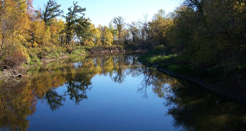
The Souris River Canoe Trail provides wonderful opportunities for wildlife viewing, passing through unique bottomland hardwood forests rich in beauty, woodlands, and wildlife.

Souris River from Johnson Bridge. Photo by Marlene Welstad / USFWS.

November sunset at the refuge. Photo by Gary Eslinger/USFWS.

Tundra swans at the refuge. Photo by Colette Guariglia/USFWS.
Location: At J. Clark Salyer National Wildlife Refuge, N of Upham, off State Route 14.
- States: North Dakota
- Counties: McHenry
Certified in 1981 this is North Dakota's only nationally recognized canoe trail and is located on the J. Clark Salyer National Wildlife Refuge. The Souris (or Mouse) River flows north here into Canada. A 5-mile route (2 to 3 hours) or a 13-mile route (5 to 7 hours) can be taken. The trail is well-marked with mile markers and three access points along the river. There are also foot trails, interpretive displays, and a visitor contact station at the Refuge Headquarters.
Accessibility Information
No text provided.
Allowed Uses:
Boating, human-powered Hiking/WalkingPublic Contact
US Fish & Wildlife Service681 Salyer Road
Upham, ND 58789
[email protected] • (701) 768-2548
www.fws.gov/jclarksalyer
More Details
- Elevation (low): --
- Elevation (high): --
- Elevation (cumulative): --
- Part of a Trail System? No
- Surface (primary): --
- Surfaces (additional): --
- Tread Width (average): 0"
- Tread Width (minimum): --
- Running length (minimum): --
- Tread Grade (average, percent): --
- Tread Grade (maximum):
- Running length (maximum): --
- Cross-slope (average, percent): --
- Cross-slope (maximum): --
- Running length (maximum): --
- Certified as an NRT
Mar 19, 1981

