Johnson Tract Trail
check with the trail manager for updated details before visiting.
Johnson Tract Trail
U.S. Corps of Engineers
Backcountry Trail
- Length
4.7 miles
- Elevation Gain
--
- Route Type
Loop
(3 reviews)
- Length
4.7 miles - Elevation Gain
-- - Route Type
Loop
The Johnson Tract Trail is a 4.7 mile, primitive National Recreation Trail. This trail is open to foot traffic only and offers outdoor enthusiasts a unique view of the Missouri Ozarks!

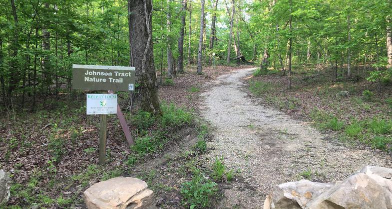
Trail entrance located off of HWY D. Photo by Donna Kridelbaugh.

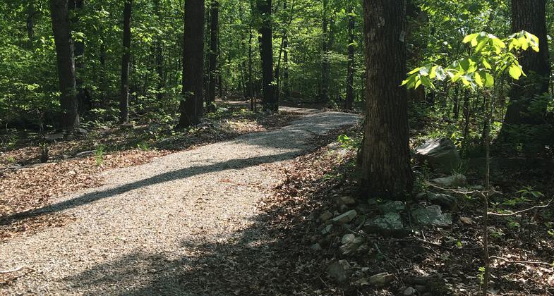
Trail features a wide gravel surface shaded by the canopy of a mixed hardwood forest. Photo by Donna Kridelbaugh.

Trail marked with \"JT\" signs. Photo by Donna Kridelbaugh.

Johnson Tract Natural Area wetlands. Photo by USACOE.
Location: Near the N end of Wappapello Lake outside Greenville.
- States: Missouri
- Counties: Wayne
- Cities/Townships: Greenville, Wappapello,
The Johnson Tract Trail is a 4.7-mile, primitive National Recreation Trail. This trail is open to foot traffic only and offers outdoor enthusiasts a unique view of the Missouri Ozarks.
The trail is located in the Johnson Tract Natural Area, an area of primarily mixed hardwood and pine forests. It follows an old roadway and meanders along ridge tops for most of its length, but also traverses a river bottom field for a short distance. Because the forested Johnson Tract is adjacent to agricultural lands, the area provides excellent habitat for many species. There are numerous opportunities for hikers to observe wildlife, including deer, wild turkey, and even beaver.
Hunting and trapping are allowed in the Johnson Tract Natural Area. No discharging of firearms or trapping within 500 feet of the parking area and/or trail is allowed. All rules and regulations governing the use of U.S. Army Corps of Engineers water resources development projects apply.
Accessibility Information
No text provided.
Reviews
Donna Kridelbaugh
NRT Ambassador Review
The Johnson Tract Nature Trail is a 4.7-mile loop trail open to pedestrian-traffic only. The trail is well maintained and provides a secluded walk through the woods with scenic features, including remnants of old homesites and wildlife-viewing opportunities. The trail was resurfaced after windstorm damage in 2017. It is now composed of a wide gravel surface for its entire length that follows the path of an old roadbed and is mostly shaded by the canopy of a mixed hardwood forest. As it is placed on a roadbed, there are some moderate grade changes where the trail transitions from ridge top to bottomland areas. To note, there is a short spur trail off the main loop that formerly led to an overlook of a wetland area, but it did not appear to be maintained at this time. Also, the designated backcountry campsites were removed when the trail was re-worked and camping is no longer allowed in this area. The trailhead is located directly off of HWY D in the Johnson Tract Natural Area of Wappapello Lake with adequate parking. There are no other amenities. While in the area, be sure to check out the four other National Recreation Trails designated in this land management unit. Please remember to leave no trace and pack out your trash while hiking the trail.
Clinton Salyer
Trail open?
Hiked this trail early summer of 2017. Got about a half mile in or so but turned around. Counted over 100 downed trees in trail. Has this section been cleared yet? I really would like to finish this trail.
Johnson Tract Trail
Hiked the trail 11/05/2017. Corps of Engineers has a closed sign at the trailhead due to a tornado or high winds that toppled many trees which are blocking and obscuring the trail. Made the hike quite a bit more challenging.
Allowed Uses:
Dogs, on leash Hiking/WalkingOther Activities
- Wildlife viewing / observation
Public Contact
Becky HaysUS Army Corps of Engineers
10992 Hwy. T
Wappapelo, MO 63966
[email protected] • (573) 778-5404
www.mvs.usace.army.mil/Missions/Recreation/Wappapello-Lake
Contact the trail manager for current maps and visiting details.
More Details
- Elevation (low): 377
- Elevation (high): 708
- Elevation (cumulative): --
- Part of a Trail System? No
- Surface (primary): Rock, crushed
- Surfaces (additional): --
- Tread Width (average): 72"
- Tread Width (minimum): 72
- Running length (minimum): --
- Tread Grade (average, percent): --
- Tread Grade (maximum):
- Running length (maximum): --
- Cross-slope (average, percent): --
- Cross-slope (maximum): --
- Running length (maximum): --
- Certified as an NRT
Oct 29, 1990


