Kingfisher Trail
check with the trail manager for updated details before visiting.
Kingfisher Trail
State
Backcountry Trail
Urban Trail
- Length
0.5 miles
- Elevation Gain
--
- Route Type
out & back
- Length
0.5 miles - Elevation Gain
-- - Route Type
out & back
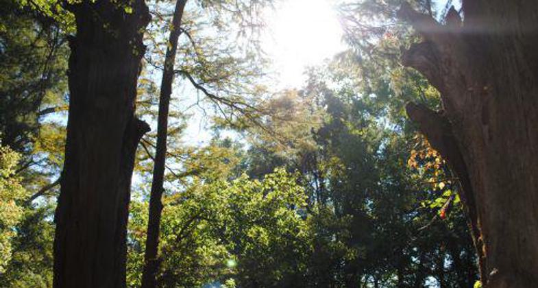
This hard-surfaced loop trail winds through the floodplain of the Little Maumelle River. Unique plants, wildflowers, animals and birds can be seen here. Along the river, large cypress trees filter sunlight into this special bottomland forest. Birdwatchers will enjoy exploring this trail early in the morning.
Location: Little Rock, At Pinnacle Mountain State Park, 10 mi. NW of Little Rock.
- States: Arkansas
- Counties: Pulaski
This hard-surfaced loop trail winds through the floodplain of the Little Maumelle River. Unique plants, wildflowers, animals, and birds can be seen here. Along the river, large cypress trees filter sunlight into this special bottomland forest. Birdwatchers will enjoy exploring this trail early in the morning.
This gentle 0.5-mile, 30-minute loop is paved and is excellent for baby strollers, the physically limited, and for exercise walking. Follow the sidewalk from the picnic area restrooms to reach the trail sign. This walk is highlighted by huge, 500-600-year-old bald cypress trees along the banks of the Little Maumelle River. This trail is a favorite for many school groups. Insect repellent may be needed during the late spring and summer months. For bird watchers, the Kingfisher offers many species during the spring migration.
Accessibility Information
No text provided.
Allowed Uses:
Dogs, on leash Hiking/WalkingOther Activities
- Wildlife viewing / observation
Public Contact
Pinnacle Mountain State Park11901 Pinnacle Valley Rd.
Little Rock, AR 72223
[email protected] • (501) 868-5806
www.arkansasstateparks.com/things-to-do/trails/kingfisher-trail-38
Contact the trail manager for current maps and visiting details.
More Details
- Elevation (low): 179
- Elevation (high): 259
- Elevation (cumulative): --
- Part of a Trail System? No
- Surface (primary): Paved
- Surfaces (additional): --
- Tread Width (average): 0"
- Tread Width (minimum): --
- Running length (minimum): --
- Tread Grade (average, percent): --
- Tread Grade (maximum):
- Running length (maximum): --
- Cross-slope (average, percent): --
- Cross-slope (maximum): --
- Running length (maximum): --
- Certified as an NRT
Apr 8, 1980