Lava River Trail
This information is a public record of the 1980 NRT application and may be out of date if it has not been updated by a trail manager --
check with the trail manager for updated details before visiting.
check with the trail manager for updated details before visiting.
Lava River Trail
USDA Forest Service
Backcountry Trail
- Length
0.5 miles
- Elevation Gain
--
- Route Type
out & back
- Length
0.5 miles - Elevation Gain
-- - Route Type
out & back
This short, paved interpretive trail offers remarkable views of lava that flowed from Yapoah Crater.
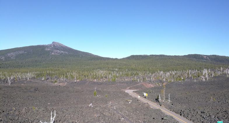
The Lava River Trail winds through a massive lava flow and features many interpretive signs. Photo by Chris Chandler.
Location: In Willamette National Forest at McKenzie Pass on SR 242, W of Sisters.
- States: Oregon
- Counties: Linn, Deschutes
Located near the Dee Wright Observatory, this paved interpretive trail offers a unique half-mile hike through lava that flowed from Yapoah Crater approximately 2,000 to 2,700 years ago. As you traverse the trail, you will find interpretive signs that offer geologic information describing the numerous lava formations along the trail.
Accessibility Information
No text provided.
Allowed Uses:
Hiking/WalkingPublic Contact
Steve OtoupalikWillamette National Forest
P.O. Box 10607 McKinzie Hwy.
McKenzie Bridge, OR 97413
[email protected] • (541) 822-3381
www.fs.fed.us/r6/willamette
Contact the trail manager for current maps and visiting details.
More Details
- Elevation (low): 5300
- Elevation (high): 5300
- Elevation (cumulative): --
- Part of a Trail System? No
- Surface (primary): Paved
- Surfaces (additional): Paved
- Tread Width (average): 36"
- Tread Width (minimum): --
- Running length (minimum): --
- Tread Grade (average, percent): 2
- Tread Grade (maximum): 10
- Running length (maximum): --
- Cross-slope (average, percent): --
- Cross-slope (maximum): --
- Running length (maximum): --
- Certified as an NRT
Aug 17, 1980