Lochsa River Historic Trail
check with the trail manager for updated details before visiting.
Lochsa River Historic Trail
USDA Forest Service
Backcountry Trail
- Length
16 miles
- Elevation Gain
--
- Route Type
out & back
(2 reviews)
- Length
16 miles - Elevation Gain
-- - Route Type
out & back

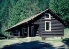
Lochsa Historical Ranger Station. Photo by JERRYE & ROY KLOTZ MD wiki.
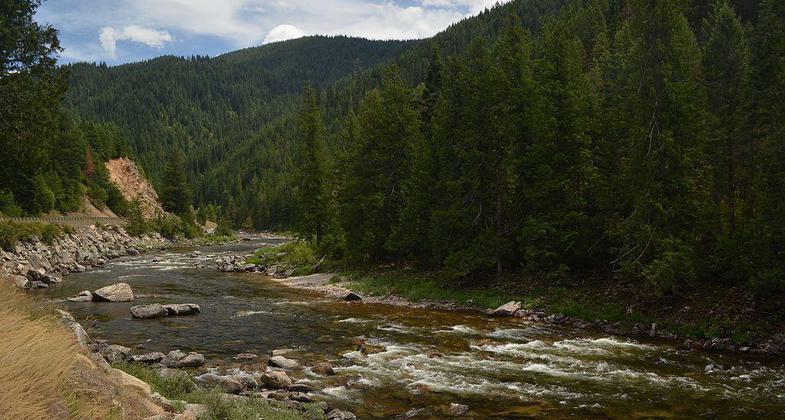
Lochsa and Selway river convulgence. Photo by Forest Service North Region.
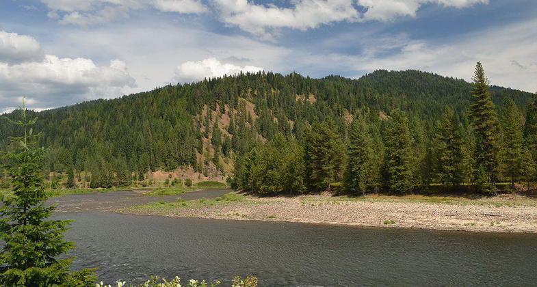
Lochsa river along National historic trail. Photo by Forest Service North Region.
Location: 121 miles east of Lewiston, ID. via Hwy 12.
- States: Idaho
- Counties: Idaho
The trail offers views of Lochsa Wild & Scenic River and the Selway-Bitterrot Wilderness.
The trail is a moderate to more than moderate elevation climb, to get up to where the trail stays somewhat in the same elevation. Because of lack of use and maintenance, the tread is grassing in, in the springtime it is a favorite place for grazing elk, so care is needed to not go off on a game trail on the switchbacks. Fantastic views and granite pillar rocks that the trail goes around and by.
Accessibility Information
No text provided.
Reviews
Dan Lynch
Beautiful but poorly maintained and no camping sites.
I went April 20 -21 starting at the Split Creek trailhead. I brought along loppers and a Silky saw intending to do some light trail maintenance along the way as is my habit. The entire trail has brush grown into the trail that the hiker must claw his way through. I used the loppers to brush the 1st mile but that took 3 hours to cover that 1 mile so it became obvious it was a lost cause and I gave up brushing. From that point on I only sawed blowdowns, but there were lots and lots of blowdowns. I got most of them within the limits of my Silky saw (about 10" diameter max) but there were several large blowdowns that I had to leave. Before I cleared the blowdowns, the trail would have been almost unusable. Now it is decent other than constantly having to push through brush. The trail starts out in mostly open country, switchbacking up the hill. Then it levels out. As you head upriver, you gradually encounter more forest until you are in shady old growth forest with lots of creeks and small water falls and ferns. It was beautiful and felt like true wilderness even though it was never far from the road. There are zero level spots along the trail where you can pitch a tent, so this trail might be better suited to a hammock-type tent that can be strung from trees.
Gail Renshaw
One of my favorite trails, for any month.
On June 3rd, 2018, I hiked up to this trail, on an old trail, not maintained, that leaves the highway at MM 114.5, across from 'Lochsa Falls', famous with river runners. The trail starts across the highway from the green mileage sign (how many miles to Lolo Pass 60, Lolo 96, Missoula 107). After getting to the trail, turning downriver, I encountered several downed trees and a major washout at the first draw, washed down to bedrock, the trail completely gone. Even with just hiking with my dog, I chose to not attempt crossing. This is upstream from Tumble Creek, which is a waterfall at the highway, across from where Old Man comes into the Lochsa River. I always recommend the short hike to Snowshoe Falls, trailhead across from the 'Wilderness' sign at approximately MM 117.5, it also is a fairly steep climb to get to this trail. On tread width, I think, 10 - 12 inches is more correct, with at times being hidden under vegetation. So, I hope there has been some maintenance, I have heard if there was more access trails it would help with the maintenance, not having it be such a long stretch to cover in one pass. I'll give it a 4 Star for it's all-season, for accesses that there are now, the views, the open areas with pillar rock , the timber cover, and especially the historical part it has played. I highly recommend Louis Hartig's book, the 'Lochsa'. From the lower end, I do not think there is a safe way to return to the highway, till the trail I used at MM 114.5, which is not clearly marked where it is at the top. I did come down to the highway along a ridge farther upriver, not a trail, but you have to be aware of where the cliffs are. The next marked trail is just upriver from Snowshoe Falls. So, that's approximately MM 111.5 - 117.5, on the highway, adding quite a bit more mileage for the ins and out of the trail.
Allowed Uses:
Bicycling Dogs, on leash Equestrian Hiking/Walking Snow, cross-country skiing Snow, snowshoeingOther Activities
- Snow, snow play general
- Wildlife viewing / observation
Public Contact
Duane AnnisClearwater National Forest
Clearwater National Forest
Orofino, ID 83544
[email protected] • (207) 476-4450
Contact the trail manager for current maps and visiting details.
More Details
- Elevation (low): 1800
- Elevation (high): 1900
- Elevation (cumulative): --
- Part of a Trail System? No
- Surface (primary): Soil
- Surfaces (additional): Soil
- Tread Width (average): 24"
- Tread Width (minimum): --
- Running length (minimum): --
- Tread Grade (average, percent): 5
- Tread Grade (maximum): 10
- Running length (maximum): --
- Cross-slope (average, percent): --
- Cross-slope (maximum): --
- Running length (maximum): --
- Certified as an NRT
Jun 11, 1991