Log Flume Interpretive Trail
This information is a public record of the 1979 NRT application and may be out of date if it has not been updated by a trail manager --
check with the trail manager for updated details before visiting.
check with the trail manager for updated details before visiting.
Log Flume Interpretive Trail
USDA Forest Service
Backcountry Trail
- Length
0.5 miles
- Elevation Gain
--
- Route Type
Loop
- Length
0.5 miles - Elevation Gain
-- - Route Type
Loop
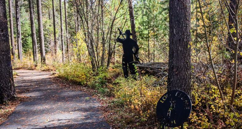
Logging during the 1920s is the story told through interpretive signs along the trail.

2023 Photo Contest Winner: Arts and Interpretation. Photo by Shelly Stevens

Along the Log Flume Interpretive Trail in the fall.

Winner 2022 NRT Photo Contest, Arts and Interpretation. Photo by Tri Co Economic.
Location: Colville National Forest, Kettle Falls, Washington
- States: Washington
- Counties: Stevens
The logging five decades ago left a significant mark on this land area. The Log Flume Trail interprets the story about the logging of the 1920s; horses pulling logs, flumes for transporting logs to the mill, and steam locomotives.
This trail was constructed by the Forest Service in the early 1970s. The site includes a barrier-free loop.
Accessibility Information
No text provided.
Allowed Uses:
Hiking/WalkingPublic Contact
USDA Forest Service, Three Rivers Ranger District255 W. 11th Avenue
Kettle Falls, WA 99141
(509) 738-7700
www.fs.usda.gov/colville
Contact the trail manager for current maps and visiting details.
More Details
- Elevation (low): --
- Elevation (high): --
- Elevation (cumulative): --
- Part of a Trail System? No
- Surface (primary): Rock, crushed
- Surfaces (additional): --
- Tread Width (average): 24"
- Tread Width (minimum): 36
- Running length (minimum): --
- Tread Grade (average, percent): --
- Tread Grade (maximum):
- Running length (maximum): --
- Cross-slope (average, percent): --
- Cross-slope (maximum): --
- Running length (maximum): --
- Certified as an NRT
Aug 12, 1979

