Long Path through Mine Kill State Park
check with the trail manager for updated details before visiting.
Long Path through Mine Kill State Park
State
Backcountry Trail
- Length
5 miles
- Elevation Gain
--
- Route Type
out & back
- Length
5 miles - Elevation Gain
-- - Route Type
out & back
The Long Path through Mine Kill State Park offers hikers an amazingly diverse blend of scenery and terrain ranging from spectacular viewpoints overlooking the Schoharie Creek and Blenheim-Gilboa Reservoir, to picturesque ravines shrouded in hemlock and white pine.
Location: Mine Kill State Park in Gilboa/North Blenheim, NY to the New York Power Authority Blenheim-Gilboa Visitor Center.
- States: New York
- Counties: Schoharie
- Cities/Townships: Gilboa, North Blenheim
The Long Path (LP) affords both the casual day hiker and seasoned long-distance backpacker outstanding opportunities to embrace the outdoors. The Long Path (LP) is an approximately 350-mile-long, scenic trail that begins at the George Washington Bridge across from Manhattan in Fort Lee, New Jersey. The LP makes its way northward along the breathtaking Palisades of the Hudson River, connecting several state, county, and local parks while heading toward the Shawangunk and Catskill Mountains. Beyond the Catskills, the LP then continues its journey along the Schoharie Valley and travels through Mine Kill State Park toward its current finishing point in Altamont, NY. Plans to extend the LP across the Mohawk River and into the Adirondacks are currently being implemented along the northernmost section of the trail.
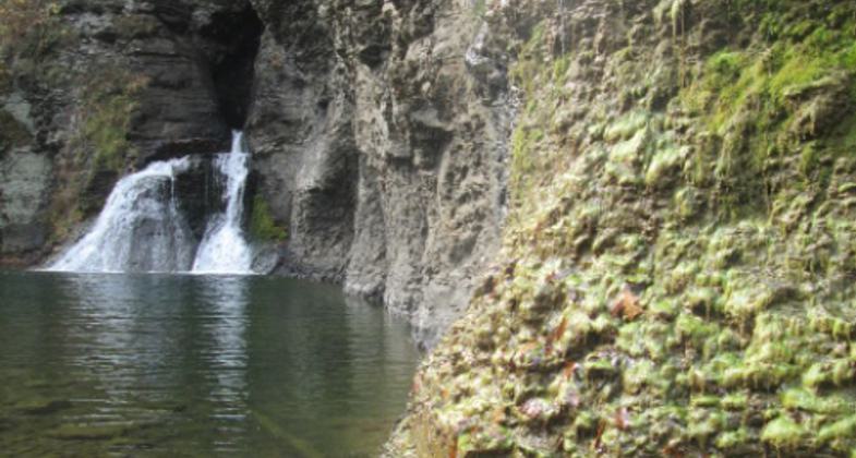
Historically, the LP was conceived by General Electric scientist Vincent Joseph Schaefer in the 1930s and was originally proposed as an unmarked route whereby a hiker would scout their own trail using landmarks, maps, and compasses. However, from the 1960s to the present day, the LP evolved as a more traditional, marked hiking trail connecting public parks and open space interspersed with road walks and sections through private land. Mine Kill State Park and the NYPA Blenheim-Gilboa Visitors Center property located in Schoharie County, New York boasts a 5-mile segment of the LP, as it enters the park along the southwestern boundary, passes at the base of the signature Mine Kill Falls, crosses Route 30 and meanders its way toward the West Kill on its way over Vroman's Nose and beyond.
The LP also intersects several of the region's other long-distance trails, including the recently developed Highlands Trail as well as the famous Appalachian National Scenic Trail. The LP's proximity to New York City, Albany, and sprawling suburbs make it highly accessible to an incredibly large population, while still maintaining a wilderness setting throughout most of its length. Individuals and groups may decide to hike just a small segment of the LP as part of an exercise regimen or may choose to challenge themselves with a multi-day adventure on a section or thru-hike of the entire trail.
Several government and non-government organizations are responsible for the maintenance and protection of the Long Path. The Palisades Interstate Park Commission and New York State Department of Environmental Conservation oversee specific sections of the LP including the Hudson Palisades region and the section within the Catskill Park, respectively. The New York-New Jersey Trail Conference based in Mahwah, NJ regularly updates maps, guidebooks, and descriptions on the Long Path and its current route. The Trail Conference also manages volunteer groups that oversee trail relocations, clean-ups, and LP extensions. The Long Path North Hiking Club serves as a subsidiary volunteer group of the Trail Conference for the section that contains Mine Kill State Park all the way to the northern terminus near Albany. The club hosts monthly guided hikes on the Long Path that include sections through Mine Kill and the NYPA property in addition to bridge construction events throughout Schoharie County.
The Long Path through Mine Kill State Park is consistently rated very highly among hikers who have experienced its natural beauty. From open bluffs with inspiring views of the Schoharie Creek to dense groves of hemlock, pine, and oak, to the tranquil Mine Kill Falls, the LP meanders its way through some of the most pristine wilderness along the entire trail. Mine Kill State Park, NYPA, and the Long Path North Hiking Club continue to support trail maintenance activities, build interpretive kiosks and monitor registers along the 5-mile LP segment within the park. This particular section of the Long Path contains a wealth of history, geology, diverse ecology, and wildlife in addition to being a fun, accessible and challenging hike for everyone.
Accessibility Information
No text provided.
Allowed Uses:
Bicycling Dogs, on leash Hiking/Walking Motorized vehicles, snowmobiling Snow, cross-country skiing Snow, snowshoeingOther Activities
- Fishing
- Heritage and history
- Hunting
- Snow, snow play general
- Wildlife viewing / observation
Public Contact
Chris KenyonMine Kill State Park
161 Mine Kill Rd
North Blenheim, NY 12131
[email protected] • 518-827-8691
Contact the trail manager for current maps and visiting details.
More Details
- Elevation (low): --
- Elevation (high): --
- Elevation (cumulative): --
- Part of a Trail System? No
- Surface (primary): Soil
- Surfaces (additional): Grass or Vegetation, Rock, crushed, Rock, smooth, Soil
- Tread Width (average): 60"
- Tread Width (minimum): 30
- Running length (minimum): --
- Tread Grade (average, percent): --
- Tread Grade (maximum):
- Running length (maximum): --
- Cross-slope (average, percent): 0
- Cross-slope (maximum): --
- Running length (maximum): --
- Certified as an NRT
Jun 2, 2014


