Lost Creek Nature Trail
check with the trail manager for updated details before visiting.
Lost Creek Nature Trail
U.S. Corps of Engineers
Backcountry Trail
- Length
1 mile
- Elevation Gain
--
- Route Type
Loop
(1 review)
- Length
1 mile - Elevation Gain
-- - Route Type
Loop
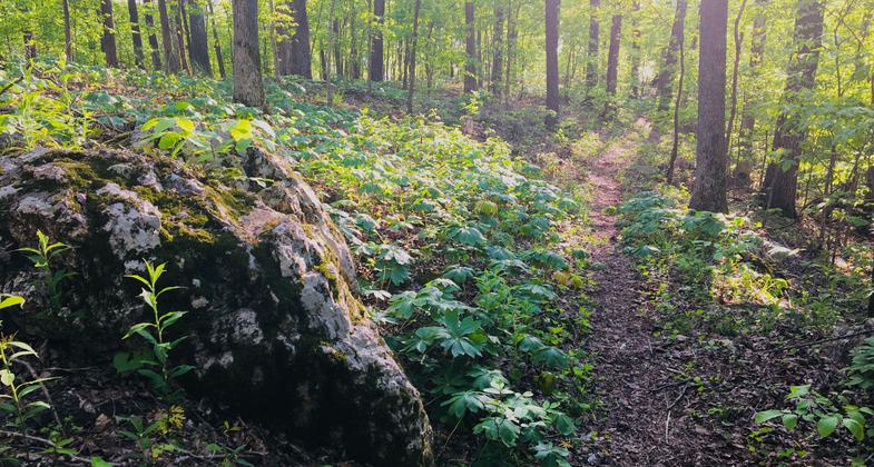
This one-mile trail has been designated as a wildlife viewing area by the Watchable Wildlife program.

2020 NRT Photo Contest Winner - Environmental Features, Flora, and Fauna. Photo by Donna Kridelbaugh.

One of two scenic overlooks providing a panoramic view of Wappapello Lake. Photo by Donna Kridelbaugh.

Access to the adjoining watchable wildlife loop near the trail entrance. Photo by Donna Kridelbaugh.

Photo by USCOE.
Location: At Lake Wappapello 16 mi. NE of Poplar Bluff.
- States: Missouri
- Counties: Wayne
- Cities/Townships: Shook, Wappapello
The Lost Creek Trail is a one-mile loop trail with a spur that leads to a bluff overlooking a portion of the Lost Creek Waterfowl Refuge. During the waterfowl season, large numbers of waterfowl may be observed from the overlook. The trail offers a variety of flora and fauna. The majority of the trail is through oak-hickory forest, although portions of the trail pass through transitional bottomland hardwoods and near the lake shoreline.
The Trail rests within the Lost Creek Waterfowl Refuge. Hunting and Trapping is allowed; however, the refuge is closed to firearms, hunting, and boat traffic during duck season. No discharging of firearms or trapping within 500 feet of the parking area and/or trail is allowed.
Accessibility Information
No text provided.
Reviews
Donna Kridelbaugh
NRT Ambassador Review
The Lost Creek Nature Trail is located at the north end of Wappapello Lake. Follow the signs for Pisos Point/Lost Creek Waterfowl Refuge from HWY D to locate the trailhead and parking lot at the terminus of CR 523. This one-mile, easy loop trail offers quiet seclusion as you pass through an oak-hickory forest and panoramic views of Wappapello Lake from two scenic overlooks along the peninsula. There is an adjoining watchable wildlife loop with access to a pond for fishing. Please leave no trace by packing out your trash and respecting wildlife when out on the trail.
Allowed Uses:
Bicycling Dogs, on leash Hiking/WalkingOther Activities
- Fishing
- Wildlife viewing / observation
Public Contact
Becky HaysUS Army Corps of Engineers
10992 Hwy. T
Wappapello, MO 63966
[email protected] • (573) 778-5404
www.mvs.usace.army.mil/Missions/Recreation/Wappapello-Lake
Contact the trail manager for current maps and visiting details.
More Details
- Elevation (low): --
- Elevation (high): --
- Elevation (cumulative): --
- Part of a Trail System? No
- Surface (primary): Soil
- Surfaces (additional): --
- Tread Width (average): 36"
- Tread Width (minimum): --
- Running length (minimum): --
- Tread Grade (average, percent): --
- Tread Grade (maximum):
- Running length (maximum): --
- Cross-slope (average, percent): --
- Cross-slope (maximum): --
- Running length (maximum): --
- Certified as an NRT
Feb 4, 1982

