Lost Lake Nature Trail
This information is a public record of the 1975 NRT application and may be out of date if it has not been updated by a trail manager --
check with the trail manager for updated details before visiting.
check with the trail manager for updated details before visiting.
Lost Lake Nature Trail
City, Town, or County
Backcountry Trail
- Length
1.25 miles - Elevation Gain
-- - Route Type
out & back
Lost Lake Nature Trail, located near Friant, California is a 1.2 mile fishing, hiking and mountain biking trail.
slide 2 of 6
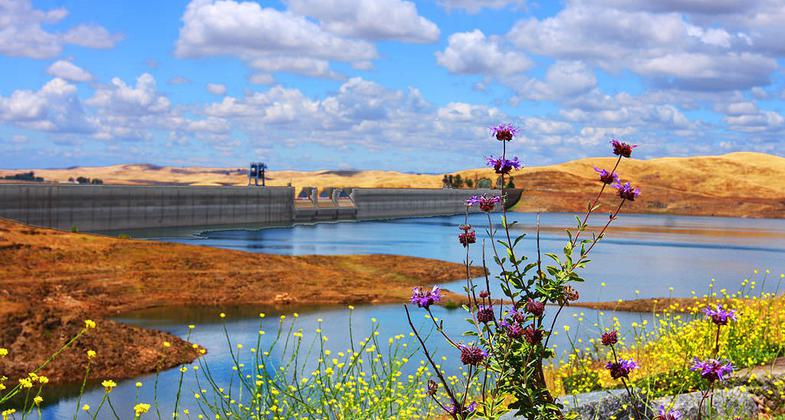
Friant Dam as seen from the Lost Lake Trail. Photo by Rennett Stowe wiki.


Location: N of Fresno, access from SR 145 at Friant Dam.
- States: California
- Counties: Fresno
The recreation area is relatively undeveloped apart from a campground, field, and day-use restrooms. The nature trail first makes an easy loop around interpretive signs bone up on your and then continues along the river for over a mile.
Accessibility Information
No text provided.
Allowed Uses:
Hiking/WalkingPublic Contact
Charles JamilFresno County Park Dept.
2220 Tulare St., # 1600
Fresno, CA 93721
(559) 488-3004
Contact the trail manager for current maps and visiting details.
More Details
- Elevation (low): --
- Elevation (high): --
- Elevation (cumulative): --
- Part of a Trail System? No
- Surface (primary): Boardwalk
- Surfaces (additional): Boardwalk
- Tread Width (average): 30"
- Tread Width (minimum): --
- Running length (minimum): --
- Tread Grade (average, percent): --
- Tread Grade (maximum):
- Running length (maximum): --
- Cross-slope (average, percent): --
- Cross-slope (maximum): --
- Running length (maximum): --
- Certified as an NRT
Sep 30, 1975