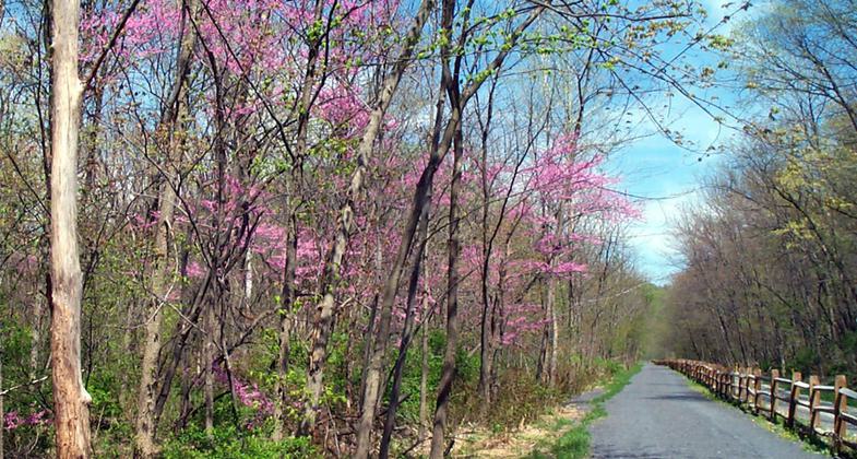
Lower Trail
check with the trail manager for updated details before visiting.
Lower Trail
- Length
16.5 miles - Elevation Gain
-- - Route Type
out & back
The Lower Trail is not only the center link in the Pittsburgh to Harrisburg Main Line Canal Greenway, it is also part of the Mid State Trail, a through hiking trail that continues north into New York State. Along its 16.5 mile corridor, the Lower Trail has many remnants of the historic Pennsylvania Main Line Canal with interpretive signage telling the history of the canal. The trail parallels the Frankstown branch of the Juniata River.
Location: 16.5 mile trail located eastern terminus Alfarata (Porter Township, Huntingdon County), western terminus Flowing Springs (Frankstown Township, Blair County)
- States: Pennsylvania
- Counties: Blair, Huntingdon
- Cities/Townships: Frankstown, Catharine, North Woodbury, Porter Townships, Williamsburg Borough
The Lower Trail is roughly a 17-mile (27 km) smooth crushed stone rail trail in West-Central Pennsylvania, owned and maintained by Rails-to-Trails of Central Pennsylvania. The trail follows the path of the abandoned Petersburg Branch of the old Pennsylvania Railroad, running along the Frankstown branch of the Juniata River between the small town of Alfarata, Huntingdon County, to Flowing Spring, Blair County (near Canoe Creek State Park). The trail is open year-round for bicycling, hiking, bird-watching cross-country skiing, and horseback riding. The trail also provides access to the Juniata River for fishing, kayaking, and canoeing.
The portion of the Lower Trail from Alfarata to Williamsburg is part of the Pennsylvania Mid State Trail and Great Eastern Trail. In addition, the site was identified as an Important Bird Area by the Ornithological Technical Committee of the Pennsylvania Biological Survey in October 2001.
The Lower Trail was developed through a combination of private and public funding. Purchase of the corridor, in 1992, from the Penn Central Corporation was made possible by a donation from Attorney T. Dean Lower of Hollidaysburg. The trail is named in memory of his late wife, Jane, and son Roger Lower. State and federal grants assisted in the construction of the trail. The trail extension, from Williamsburg to Canoe Creek, was made possible by an anonymous donation for the land purchase, and once again state and federal grants facilitated the design and construction of the trail.
Blessed with a wide corridor and natural scenic beauty, the Lower Trail is one of the premier trails in the Commonwealth. The trail is open to all non-motorized uses including hiking, bicycling, horseback riding, and cross-country skiing. There is also excellent fishing and canoeing/kayaking in the Juniata River's Frankstown Branch, as well as hunting on private property and State Game Lands adjacent to the trail.
Stretching 16.5 miles from Alfarata in Huntingdon County to Flowing Spring, the Trail follows the route of the Petersburg Branch of the old Pennsylvania Railroad alongside the Frankstown Branch of the Juniata River. Long used as a transportation corridor, this was also the route of the Upper Juniata Division of the Pennsylvania Canal. Many canal-related features can be found along the trail including canal locks, foundations of lock tenders' houses, and aqueduct stonework. Other industrial heritage features are also visible along the trail including several stone quarries, building foundations related to the company town of Carlim and the Juniata Limestone Company, and the Mt. Etna Iron Furnace complex.
The Lower Trail is unique in that it is privately owned, yet open free of charge to the public and maintained totally by volunteers. Rails-to-Trails of Central PA, Inc. has no paid employees, and all upkeep, maintenance, and repairs are made with volunteer help. Improvements such as pavilions, benches, rain shelters, and the Grannas Station trail headquarters building are funded through private donations and built with volunteer labor.
The Lower Trail offers a relatively level terrain for bike riding made mostly of crushed stone with a two-mile asphalt section at the Williamsburg trailhead. The trail is 8 feet wide and has grassy areas on either side of the stone path for horseback riding. It closely follows the Frankstown Branch of the Juniata River, offering unique glimpses of the wildlife and forests of central Pennsylvania.
The Lower Trail has six primary trailheads. All trailheads have abundant parking, with pavilions/picnic tables available.
Accessibility Information
No text provided.
Allowed Uses:
Bicycling Boating, human-powered Dogs, on leash Equestrian Hiking/Walking Snow, cross-country skiingOther Activities
- Fishing
- Hunting
- Snow, snow play general
- Wildlife viewing / observation
Public Contact
Jennifer BarefootRails to Trails of Central PA, Inc.
Rails to Trails of Central PA, Inc.
Hollidaysburg, PA 16648
(814) 832-2400
www.rttcpa.org
Contact the trail manager for current maps and visiting details.
More Details
- Elevation (low): 720
- Elevation (high): 900
- Elevation (cumulative): --
- Part of a Trail System? No
- National Designations: Legacy Millenium
- Surface (primary): Rock, crushed
- Surfaces (additional): Paved, Grass or Vegetation, Rock, crushed
- Tread Width (average): 0"
- Tread Width (minimum): --
- Running length (minimum): --
- Tread Grade (average, percent): --
- Tread Grade (maximum):
- Running length (maximum): --
- Cross-slope (average, percent): --
- Cross-slope (maximum): --
- Running length (maximum): --
- Certified as an NRT
May 25, 2009


