Mahoning Shadow Trail
check with the trail manager for updated details before visiting.
Mahoning Shadow Trail
City, Town, or County
Backcountry Trail
Frontcountry Trail
Urban Trail
- Length
15 miles
- Elevation Gain
--
- Route Type
out & back
- Length
15 miles - Elevation Gain
-- - Route Type
out & back
The Mahoning Shadow Trail follows the path of the Mahoning Creek in the Pennsylvania counties of Jefferson and Indiana.

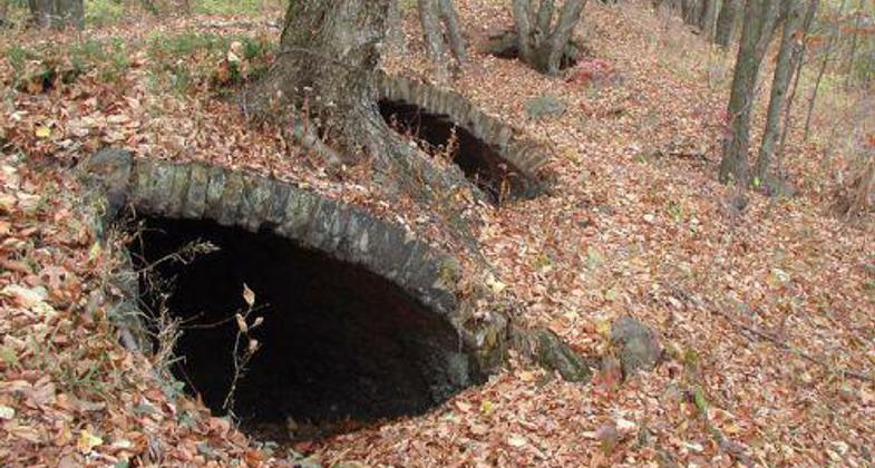
Part of the trail runs along a series of well-preserved coke ovens.


Inside a Coke Oven. Photo by Mary Shaw.
Location: Punxsutawney, Bell Twp., Young., Perry Twp., Jefferson Co., PA
- States: Pennsylvania
- Counties: Jefferson, Indiana
The trail provides an alternate route that connects several small communities located on either side of the Borough of Punxsutawney. Its many entrances give users easy access to the trail. People of all ages and all levels of fitness enjoy hiking, walking, and naming on the trail in more temperate weather and snow-shoeing and cross-country-skiing when wintry conditions prevail. Because of its proximity to several elementary schools, teachers have been able to use the Mahoning Shadow Trail for lessons ranging from geometry to physical fitness. The trail provides an excellent view of the historic coke ovens that remind Trail users of the area's coal-mining and railroad heritage.
The wildlife found on the trail includes deer, rabbits, squirrels, and relatives of Punxsutawney's most famous citizen, the weather-forecasting groundhog Phil. The flora features numerous species of trees and abundant wildflowers, including the rare pink lady-slipper. On cliffs and hillsides that overlook the trail can be found waterfalls and intriguing rock formations. The beauty and tranquility of the Mahoning Shadow Trail guarantee that its visitors will return again and again.
Accessibility Information
No text provided.
Allowed Uses:
Bicycling Boating, human-powered Hiking/Walking Snow, cross-country skiing Snow, snowshoeingOther Activities
- Camping
- Fishing
- Snow, snow play general
- Wildlife viewing / observation
Public Contact
Craig CoonJefferson Co. Dept. of Development
155 Main St., 2nd floor
Brookville, PA 15825
[email protected] • (814) 849-3047
Contact the trail manager for current maps and visiting details.
More Details
- Elevation (low): 1200
- Elevation (high): 1600
- Elevation (cumulative): --
- Part of a Trail System? No
- Surface (primary): Rock, crushed
- Surfaces (additional): Rock, crushed
- Tread Width (average): 127"
- Tread Width (minimum): --
- Running length (minimum): --
- Tread Grade (average, percent): --
- Tread Grade (maximum): 8
- Running length (maximum): --
- Cross-slope (average, percent): --
- Cross-slope (maximum): --
- Running length (maximum): --
- Certified as an NRT
May 31, 2006

