Metolius-Windigo Trail
This information is a public record of the 1980 NRT application and may be out of date if it has not been updated by a trail manager --
check with the trail manager for updated details before visiting.
check with the trail manager for updated details before visiting.
Metolius-Windigo Trail
USDA Forest Service
Backcountry Trail
- Length
120 miles
- Elevation Gain
--
- Route Type
out & back
- Length
120 miles - Elevation Gain
-- - Route Type
out & back
The Metolius-Windigo Trail is a 120-mile backcountry trail from the head of the Metolius River to Windigo Pass.
A view of South Sister from the Metolius-Windigo Trail. Photo by Kim McCarrel.

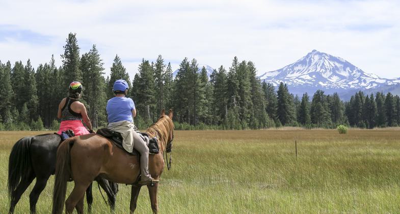
Winner 2024 NRT Photo Contest, Equestrian Trails

Southern Terminus. Photo by Vittles.

Ultralight packing on the Metolius-Windigo Trail near Three Creek Meadow Horse Camp. Photo by Kim McCarrel.

In the Metolius Basin, on the Metolius-Windigo Trail. Photo by Kim McCarrel.

In the Many Lakes Basin, on the Metolius-Windigo Trail. Photo by Kim McCarrel.

Crossing Whychus Creek, on the Metolius-Windigo Trail. Photo by Kim McCarrel.

At Kershaw Lake, on the Metolius-Windigo Trail in the Many Lakes Basin. Photo by Kim McCarrel.

An equestrian and a hiker do a meet and greet on the Metolius-Windigo Trail. Photo by Kim McCarrel.

A view of the Three Sisters from the Metolius-Windigo Trail near Sisters, Oregon. Photo by Kim McCarrel.
Location: Deschutes National Forest
- States: Oregon
- Counties: Deschutes
The Metolius-Windigo Trail goes from the head of the Metolius River in the Sisters Ranger District, across the Bend-Fort Rock Ranger District, and then down to Windigo Pass in the Crescent Ranger District. Along the way, especially in the Bend-Fort Rock Ranger District, it follows other trails to form a continuous route from north to south. A good map of the route of this trail is essential when planning a trip from start to finish.
Accessibility Information
No text provided.
Allowed Uses:
Bicycling Dogs, on leash Equestrian Hiking/WalkingOther Activities
- Camping
- Fishing
Public Contact
Marv LangDeschutes National Forest
Bend-Fort Rock Rd.
Bend, OR 97701
[email protected] • (541) 383-4793
www.fs.fed.us/r6/centraloregon
Contact the trail manager for current maps and visiting details.
More Details
- Elevation (low): 4600
- Elevation (high): 6900
- Elevation (cumulative): --
- Part of a Trail System? No
- Surface (primary): Soil
- Surfaces (additional): --
- Tread Width (average): 14"
- Tread Width (minimum): --
- Running length (minimum): --
- Tread Grade (average, percent): 8
- Tread Grade (maximum): 12
- Running length (maximum): --
- Cross-slope (average, percent): --
- Cross-slope (maximum): --
- Running length (maximum): --
- Certified as an NRT
May 17, 1980