Monte Sano Nature Preserve Trail System
check with the trail manager for updated details before visiting.
Monte Sano Nature Preserve Trail System
Nonprofit
Backcountry Trail
Frontcountry Trail
Rail Trail
Urban Trail
- Length
20 miles
- Elevation Gain
--
- Route Type
Loop
- Length
20 miles - Elevation Gain
-- - Route Type
Loop
The Monte Sano Nature Preserve offers 1,107 acres and 20.3 miles of public trails for hiking, biking, environmental education, bird watching, picnicking, and reflection. The Preserve is the scenic backdrop for the city of Huntsville, Alabama, and is the home of what remains of the Monte Sano Railway, historic Three Caves Quarry, Civil War landmark Trough Springs, and popular Wildflower Trail. The Monte Sano Nature Preserve is one of three Land Trust of North Alabama Preserves that are each larger than Central Park and are all within Huntsville city limits.
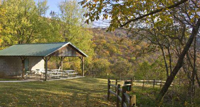
Monte Sano Nature Preserve Environmental Education Picnic Pavilion in Fall. Photo by Jerry Green

Winner 2022 NRT Photo Contest, Hiking and Walking. Photo by Jim Teed.
Location: Monte Sano Mountain in Huntsville, AL
- States: Alabama
- Counties: Madison
- Cities/Townships: Huntsville
The Monte Sano Nature Preserve offers 1,107 acres and 20.3 miles of public trails for hiking, biking, environmental education, bird watching, picnicking, and reflection. The Preserve is the scenic backdrop for the city of Huntsville, Alabama, and is the home of what remains of the Monte Sano Railway, historic Three Caves Quarry, Civil War landmark Trough Springs, and popular Wildflower Trail. The Monte Sano Nature Preserve is one of three Land Trust of North Alabama Preserves that are each larger than Central Park and are all within Huntsville city limits.
The wooded slopes of the Land Trust of North Alabama's Monte Sano Nature Preserve create the scenic backdrop for the city of Huntsville, Alabama. 1,107 acres and 20.3 miles of public trails offer opportunities for hiking, biking, environmental education, bird watching, picnicking, and reflection. The variety of trail difficulty - from easy to very difficult - appeals to all ages and abilities. The Monte Sano Nature Preserve is one of three Land Trust Preserves that are each larger than Central Park and are all within Huntsville city limits.
Huntsville/Madison County's mountains form the final segment of the Great Appalachian chain and provide some of the southernmost habitats of broadleaf hardwoods such as the Sugar Maple. Monte Sano is home to several plant species important to the study of ecosystem stability referred to by scientists as"relics," because they provide clues to the climate of periods hundreds of thousands of years ago. Some of these species include the American Smoketree (Chittamwood), Morefield's Leather Flower, Price's Potato Bean, and Cumberland Rosinweed.
Volunteers have created and maintained this multi-use trail system for passive non-motorized recreation. The Preserve's 27 named trails include a Rails-to-Trails designee (Old Railroad Bed Trail); a regional birdwatcher favorite (Fagan Creek Trail where over 150 species of birds, 70 of which are uncommon, have been sighted); a historic Civil War landmark (Trough Springs Trail); a former limestone quarry named Three Caves which has been the setting for several movies; the purported route of the James Gang's 1883 daring escape following a downtown Huntsville bank robbery; the"killer" part of Alabama's"Toughest Trail Run" - the Mountain Mist 50K (Waterline Trail); and spring wildflower mecca (Wildflower Trail along Fagan Creek).
Both the city of Huntsville and the Land Trust own land which comprise the Preserve, with the Land Trust providing management and trail development/maintenance. The Land Trust's Public Recreation Committee is responsible for identifying, prioritizing, planning, implementing, and maintaining all recreational development including trail development and trailheads on properties opened to the public. In addition, this committee works closely with the Volunteer Coordinator to recruit, develop, and nurture volunteers needed to support their efforts. This committee is also responsible for all mapping and GIS-gathering efforts. The Land Trust staff representatives on the Public Recreation Committee are the Land Manager and the Land Steward.
The Land Trust offers environmental outreach programs. Seasonal hikes and events offer a gateway to use and direct enjoyment of Land Trust trails, increasing the probability of self-initiated usage. Environmental education events on the trails help foster an appreciation of nature and the need to preserve the places we love. This is vital in raising the next generation of land preservationists.
Other organized groups such as the Sierra Club, Wildflower Society, OLLI (Osher Lifelong Learning Institute), classes from Alabama A&M University, University of Alabama in Huntsville, and homeschool and Scout groups are but a few who consistently use these trails that are open to the public.
The Preserve's trails are also connected to Huntsville's greenways as portions of the Big Spring, Chapman Mountain, and Spacewalk Section I Greenways. Partnerships with the city of Huntsville, the Monte Sano State Park, and Alabama's Forever Wild have helped create a trail system that attracts residents and area visitors alike.
Accessibility Information
No text provided.
Allowed Uses:
Bicycling Dogs, on leash Hiking/WalkingOther Activities
- Heritage and history
- Wildlife viewing / observation
Public Contact
Cathie MayneLand Trust of North Alabama
907 Franklin Street
Huntsville, AL 35801
[email protected] • (256) 534-5263
Contact the trail manager for current maps and visiting details.
More Details
- Elevation (low): 700
- Elevation (high): 1500
- Elevation (cumulative): --
- Part of a Trail System? No
- National Designations: One of 1st 500 Rails-toTrails Conservancy Projects
- Surface (primary): Soil
- Surfaces (additional): Grass or Vegetation, Rock, boulders, Rock, crushed, Rock, smooth, Soil
- Tread Width (average): 20"
- Tread Width (minimum): 18
- Running length (minimum): --
- Tread Grade (average, percent): 6
- Tread Grade (maximum): 25
- Running length (maximum): --
- Cross-slope (average, percent): 0
- Cross-slope (maximum): --
- Running length (maximum): --
- Certified as an NRT
May 29, 2012