Mount Charleston
This information is a public record of the 1979 NRT application and may be out of date if it has not been updated by a trail manager --
check with the trail manager for updated details before visiting.
check with the trail manager for updated details before visiting.
Mount Charleston
USDA Forest Service
Backcountry Trail
- Length
8 miles
- Elevation Gain
--
- Route Type
out & back
- Length
8 miles - Elevation Gain
-- - Route Type
out & back
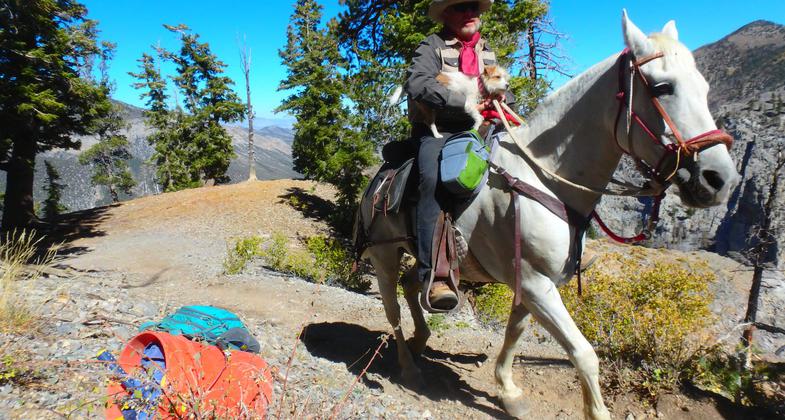
Big Jim, of the Backcountry Horseman, and his dog, Millie, both on their way to bring tools and supplies up to the crew. Photo by Liam Downs-Tepper.

Wildflowers on the Echo Trail. Photo by Ruhi-Varatkar.

A Nevada Conservation Corps Trail Crew enjoys a well-earned break the week before the reopening of the South Loop Trail. Photo by Liam Downs-Tepper.

Nevada Conservation Corps. crew member Liam Downs-Tepper enjoys a moonlit night. Photo by Liam Downs-Tepper.

Nevada Conservation Corps. crew member Drake Sweet has a heart to heart with one of the horses that delivered gear to the NCC. Photo by Liam Downs-Tepper.

A Nevada Conservation Corps Trail Crew enjoys a well-earned break the week before the reopening of the South Loop Trail. Photo by Liam Downs-Tepper.
Location: Mount Charleston Wilderness, In Toiyabe National Forest, NW of Las Vegas, at Cathedral Rock Picnic Area in Upper Kyle Canyon
- States: Nevada
- Counties: Clark
The Mount Charleston NRT climbs up a steep ridge out of Echo Canyon. Along the way, there are many dramatic views of Echo and Kyle Canyons. The trail ascends through one of the largest ancient bristle cone pine forests in the nation. Some of these magnificent trees are over 3000 years old. The trail continues on through green meadows before entering the rugged, barren rock area of the 11,900-foot peak. At the peak are breathtaking views of Las Vegas and the surrounding desert valleys.
Accessibility Information
No text provided.
Allowed Uses:
Dogs, on leash Equestrian Hiking/Walking Snow, cross-country skiing Snow, snowshoeingOther Activities
- Camping
- Snow, snow play general
Public Contact
Scott LamoreuxHumboldt - Toiyabe National Forest
1200 Franklin Way
Sparks, NV 89431
[email protected] • (775) 355-5301
www.fs.fed.us/htnf
Contact the trail manager for current maps and visiting details.
More Details
- Elevation (low): 7600
- Elevation (high): 11900
- Elevation (cumulative): --
- Part of a Trail System? No
- Surface (primary): Soil
- Surfaces (additional): Soil
- Tread Width (average): 48"
- Tread Width (minimum): --
- Running length (minimum): --
- Tread Grade (average, percent): 10
- Tread Grade (maximum):
- Running length (maximum): --
- Cross-slope (average, percent): --
- Cross-slope (maximum): --
- Running length (maximum): --
- Certified as an NRT
Nov 15, 1979