Mount Blue Sky
check with the trail manager for updated details before visiting.
Mount Blue Sky
USDA Forest Service
Backcountry Trail
- Length
0.3 miles
- Elevation Gain
--
- Route Type
out & back
(1 review)
- Length
0.3 miles - Elevation Gain
-- - Route Type
out & back
The trail is a .30 mile hiking trail to the top of 14,264 foot Mount Blue Sky, with expansive views in all directions.

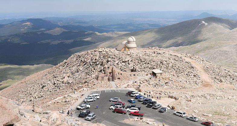
View from the summit of Mount Blue Sky onto the end of the scenic byway and the observatory. Photo by Daniel Schwen/wiki.

The former Crest House built on the summit of then Mt. Blue Sky. Photo by Jay Poules.

Mount Blue Sky Mountain Goats. Photo by Robertbody/wiki.

Summer crowds on Mount Blue Sky summit. Photo by Alan Franklin/wiki.
Location: 28 miles south of Idaho Springs, CO on CO Highways 103 and 5, beginning at the parking lots at the end of CO Highway 5, near the summit of Mt. Blue Sky.
- States: Colorado
- Counties: Clear Creek
Dominating the skyline west of Denver, the summit of Mount Blue Sky has long been a popular destination for Denverites. Originally named Mount Rosalie by the painter Albert Bierstadt, it was later renamed Mount Evans for the second territorial governor of Colorado, John Evans. In 2023 the name was changed to Mount Blue Sky, honoring the indigenous Arapaho and Cheyenne tribes.
With the creation of Rocky Mountain National Park in 1915, Mount Blue Sky and the surrounding area were also proposed for national park status, but this never came to pass. In 1921, the state of Colorado began construction of what is now Highway 5 to the summit of Mount Blue Sky. The road reached the summit in 1927. In 1941, a restaurant and gift shop called the Crest House was constructed at the end of the road. Unfortunately, the Crest House burned in 1979, and its stone walls are all that remain. In 1942, a fire lookout was constructed on the Mount Blue Sky summit, but it remained for only a couple of years. During World War II, the road was closed to public use and used by the Army as an arctic training area. In 1945, the road was reopened and the trail to the summit from the parking area was improved. The trail was designated a National Recreation Trail in 1979.
The boundary of the Mount Evans Wilderness crosses the summit of Mount Blue Sky, as does the boundary between the Pike and Arapaho National Forests. Although the trail is maintained and managed by the Arapaho National Forest, the trail is technically on the Pike.
Although the trail is never closed to use, the road to the trailhead is closed to motorized use from Labor Day until Memorial Day.
Accessibility Information
No text provided.
Reviews
start slow
loved the little hike up there, i took off running and got very lightheaded. I grew up in Colorado and have summited a few 14ers. just remember, do not get too excited . take your time. even though its so short.
Allowed Uses:
Dogs, on leash Hiking/WalkingOther Activities
- Wildlife viewing / observation
Public Contact
Ralph BradtUS Forest Service, Clear Creek Ranger District
PO Box 3307
Idaho Springs, CO 80452
[email protected] • (303) 567-3017
Contact the trail manager for current maps and visiting details.
More Details
- Elevation (low): 14127
- Elevation (high): 14264
- Elevation (cumulative): --
- Part of a Trail System? No
- Surface (primary): Rock, smooth
- Surfaces (additional): Rock, smooth
- Tread Width (average): 24"
- Tread Width (minimum): --
- Running length (minimum): --
- Tread Grade (average, percent): 5
- Tread Grade (maximum): 10
- Running length (maximum): --
- Cross-slope (average, percent): --
- Cross-slope (maximum): --
- Running length (maximum): --
- Certified as an NRT
Dec 12, 1979

