Mount Si Trail
check with the trail manager for updated details before visiting.
Mount Si Trail
State
Backcountry Trail
- Length
4 miles
- Elevation Gain
--
- Route Type
out & back
- Length
4 miles - Elevation Gain
-- - Route Type
out & back
Mount Si is one of the most popular hiking destinations in the state, as its looming peak, so near to the Seattle metropolitan area gives a real taste of the rugged Cascades. Its many switchbacks serve as training grounds for aspiring mountaineers and its wide path allows families to walk in stride. All visitors are inspired by the majestic beauty of the views of Puget Sound and the Olympic Mountains from atop the peak.
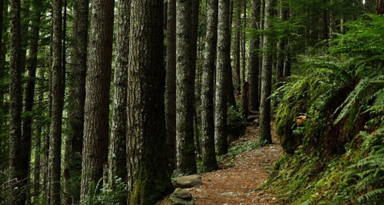
A lush forest surrounds the Mount Si Trail. Photo by Noah Pylvainen

A view of Mount Si from Snoqualmie Point Park.

Location: Trail ascends the south face of Mount Si, just east of North Bend, WA.
- States: Washington
- Counties: King
- Cities/Townships: n/a
Mount Si is one of the most popular hiking destinations in the state, as its looming peak, so near to the Seattle metropolitan area gives a real taste of the rugged Cascades. Its many switchbacks serve as training grounds for aspiring mountaineers and its wide path allows families to walk in stride. All visitors are inspired by the majestic beauty of the views of Puget Sound and the Olympic Mountains from atop the peak.
As a pinnacle in prehistoric and contemporary folklore and a hiking mecca, Mount Si is a regional and national treasure. The Mount Si Trail's distinctive natural and cultural heritage is unique in the country.
The mountain itself is a dominant landmark in the region. The western face that Si shows to the world is a towering rock cliff that gives the impression of being recently thrust from the wide floodplain of the Snoqualmie River Valley. For the millions that drive east on Interstate 90, the Mountains to Sound Greenway National Scenic Byway, Mount Si leaps into view just past the crest of a ridge only 28 miles on the road from Seattle.
The imposing terrain of Mount Si pervades the lives of those that live in its shadow and gaze on its face. From time immemorial the people of the Snoqualmie Tribe have lived near Mount Si, which formed when Snoqualm, the Moon, fell to earth. Some say you can still see the face of Snoqualm on the rock surface of the summit.
In the nearby cities of Snoqualmie and North Bend, dozens of businesses, schools, and organizations show their respect by using the name of the mountain as their own: Mount Si High School, Mount Si Golf Course, and Mount Si Senior Center. The landmark mountain also inspired the 1990s television show Twin Peaks to film in North Bend; every episode uses a shot of Mount Si in the opening credits.
The peak had long been a popular hiking destination. In fact, in 1907, the nationally famous Mountaineers Club made Mount Si their first official conquest, riding to Snoqualmie by train. Now it's one of the most popular hiking destinations in the state, over 100,000 hikers visit the Mount Si Trail every year, partially thanks to the attractively short 40-minute drive from Seattle.
The Mount Si Trail's great reputation means that people of all kinds from the nearby metropolitan area visit the trail. Any visitor is bound to hear more languages spoken by fellow hikers than they can interpret. The 3,150 feet of elevation gain, strenuous but doable on the well-switchbacked ascent, makes the trail a training ground for mountaineers, high-altitude trekkers, military troops, and others looking for strenuous conditioning.
The mountain and trail haven't always enjoyed the protections they have now. In 1976, a quarry operation threatened the mountain's serene beauty, so locals appealed to their state representative, Francis North. Representative North introduced an act to encourage the Washington Department of Natural Resources (DNR) to study the preservation of the natural form and scenic value of the area. In 1987 Mount Si became one of the state's first Natural Resources Conservation Areas (NRCA). The size of the NRCA when it was designated in 1987 was 4,670 acres and has now been expanded to 13,363 acres to conserve more of the surrounding lands.
A decade after the original trail was built in 1990 heavy use had worn it down, eroding slopes and leaving a rocky surface for hikers. The state DNR, aided by two $50,000 grants from the National Recreation Trails Program through the state Interagency Committee for Outdoor Recreation, embarked on a multi-year reconstruction. The restoration was only possible through an extremely collaborative effort. The Mountains to Sound Greenway Trust and Washington Trails Association led 200 volunteer events, contributing 13,300 volunteer hours, to re-excavate the trail tread, build retaining walls, install drainage structures, build rock and timber steps, and harden the trail.
The current trail ascends steadily through steady switchbacks for its first mile and a half. At that point, Snag Flats offers a respite from the climb with a short interpretive spur trail to a stand of old-growth trees that have survived both fire and logging. Beyond, the trail steepens, climbing through a younger forest with a view south through the canopy at three and a half miles. At four miles, the main summit reveals stunning views of Snoqualmie Valley, Seattle's skyline, and across Puget Sound to the Olympic mountain range.
Use of the trail and surrounding areas is governed by the Mount Si NRCA Public Use Plan, which provides guidelines for safe, low-impact recreation to ensure that future generations will have the opportunity to enjoy the area's special resources. Hikers are required to purchase a Discover Pass when using state recreation lands; funds from the Pass help keep trails maintained. The 160-car parking lot at the trailhead of Mount Si offers accessible restrooms, a picnic area, and interpretive viewing decks, as well as a kiosk illustrating the connection of this trail to the Mountains to Sound Greenway landscape.
As one of the most popular hikes in the Pacific Northwest and an iconic mountain that has inspired storytellers for generations, the Mount Si Trail is a clear fit for the National Recreation Trail designation.
Accessibility Information
No text provided.
Allowed Uses:
Hiking/WalkingPublic Contact
Sam JarrettWashington Department of Natural Resources
950 Farman Ave North
Enumclaw, WA 98022
[email protected] • (206)375-0448
Contact the trail manager for current maps and visiting details.
More Details
- Elevation (low): 750
- Elevation (high): 3900
- Elevation (cumulative): --
- Part of a Trail System? No
- Surface (primary): Soil
- Surfaces (additional): Rock, boulders, Rock, crushed, Rock, smooth
- Tread Width (average): 36"
- Tread Width (minimum): 24
- Running length (minimum): --
- Tread Grade (average, percent): 12
- Tread Grade (maximum): 15
- Running length (maximum): --
- Cross-slope (average, percent): 45
- Cross-slope (maximum): --
- Running length (maximum): --
- Certified as an NRT
Jun 3, 2015