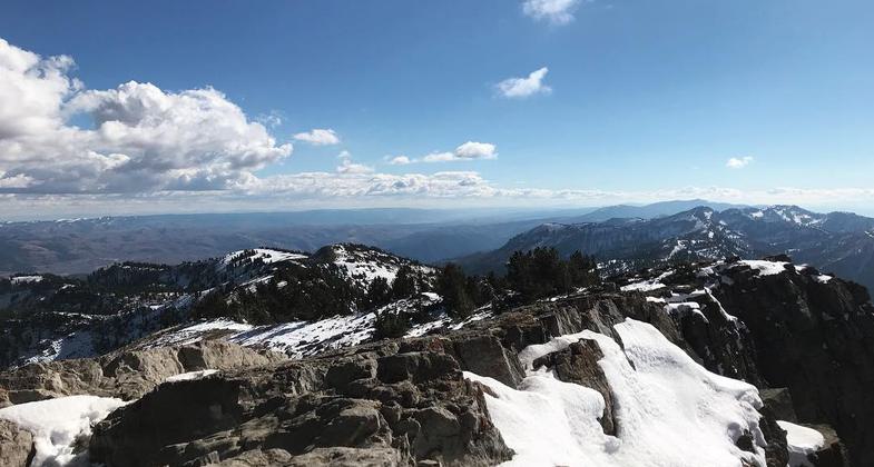
Mt. Naomi Peak Trail
This information is a public record of the 1979 NRT application and may be out of date if it has not been updated by a trail manager --
check with the trail manager for updated details before visiting.
check with the trail manager for updated details before visiting.
Mt. Naomi Peak Trail
USDA Forest Service
Backcountry Trail
- Length
9 miles
- Elevation Gain
--
- Route Type
out & back
- Length
9 miles - Elevation Gain
-- - Route Type
out & back
Location: Access is from Tony Grove Trailhead, northeast of Logan via Logan Canyon Highway or from High Creek Trailhead northeast of Richmond. In Wasatch NF, NE of Logan on US 89 W of Garden City.
- States: Utah
- Counties: Cache
The actual trail is 24 miles long and goes from Green Canyon near Logan to the High Creek Trailhead near Richmond. The actual NRT runs from Tony Grove Lake Trailhead to the High Creek Trailhead and is approximately 9 miles long. Most of the trail is within the Mount Naomi Wilderness and wilderness regulations apply. The actual summit of Naomi Peak is reached by a side trail 0.2 miles long. The trail has both day use and overnight use and both hiking and horseback use.
Accessibility Information
No text provided.
Allowed Uses:
Dogs, on leash Hiking/Walking Snow, cross-country skiing Snow, snowshoeingOther Activities
- Snow, snow play general
- Wildlife viewing / observation
Public Contact
USFS Wasatch-Cache National Forest Logan RDLogan Ranger District
Logan, UT 84321
(435) 755-3620
www.fs.fed.us/r4/wcnf
Contact the trail manager for current maps and visiting details.
More Details
- Elevation (low): 5500
- Elevation (high): 9900
- Elevation (cumulative): --
- Part of a Trail System? No
- Surface (primary): Soil
- Surfaces (additional): Soil
- Tread Width (average): 24"
- Tread Width (minimum): --
- Running length (minimum): --
- Tread Grade (average, percent): 12
- Tread Grade (maximum): 25
- Running length (maximum): --
- Cross-slope (average, percent): --
- Cross-slope (maximum): --
- Running length (maximum): --
- Certified as an NRT
Dec 12, 1979