Mud Pond Trail
check with the trail manager for updated details before visiting.
Mud Pond Trail
U.S. Fish and Wildlife Service
Backcountry Trail
- Length
0.6 miles
- Elevation Gain
--
- Route Type
out & back
(2 reviews)
- Length
0.6 miles - Elevation Gain
-- - Route Type
out & back
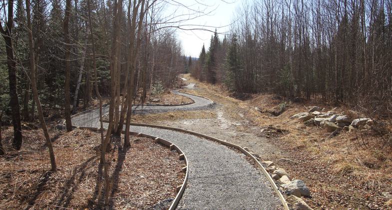
A wheelchair accessible trail and boardwalk to a northern white cedar and black spruce seepage swamp and a fen around Mud Pond.

Wheelchair accessible Mud Pond Trail. Photo by David Govatski

Mud Pond Trail Observation Deck. Photo by David Govatski.

Trailhead. Photo by Janie Walker.

Mud Pond at sunset. Photo by Patricia Ellis Herr.

Aerial Photo showing the Mud Pond Trail.

Wildlife Crossing on Mud Pond Trail Boardwalk.

Observation platform at Mud Pond.

Rhodora at Mud Pond.

Boardwalk on the Mud Pond Trail on a rainy day.

Snowshoe Hare on Mud Pond Trail.
Location: Pondicherry National Wildlife Refuge near Jefferson, New Hampshire.
- States: New Hampshire
- Counties: Coos
- Cities/Townships: Jefferson
The Mud Pond Trail is on the Pondicherry Division of the Silvio O. Conte National Wildlife Refuge and is universally accessible. The trail was constructed by the Youth Conservation Corps, US Fish, and Wildlife Service staff, and volunteers from the Friends of Pondicherry over a five-summer period. The trail has a 900-foot-long raised boardwalk with rest stops that offer extraordinary views of a boreal forest and wetland communities.
Visitors walk through a forest community uncommon to the Connecticut River Valley to a beautiful pond and fen deep within the refuge. Benches allow visitors to sit and observe the wildlife, plant communities, and scenery. Mud Pond is home to three carnivorous plants and unusual wildlife for this part of New England, including the Arctic Jutta butterfly, black-backed woodpecker, gray jay, boreal chickadee, yellow-bellied flycatcher, and palm warbler. Moose, black bears, and snowshoe hares are sometimes seen along the trail.
The trailhead was built on a restored log landing and some of the trail follows old logging roads that are being restored. The boardwalk portion is in older forests that have not been harvested for over a century. The trail takes visitors, including those in strollers and wheelchairs on a unique raised boardwalk providing an experience, found nowhere else in New Hampshire. The trail is located in the White Mountains of New Hampshire where opportunities for wheelchair-accessible trails in this mountainous region are limited. The trail is used by local residents, visitors staying at nearby resorts, school groups families with children in strollers, and people confined wheelchairs.
The future plan for the trail is to provide interpretive panels and online resources to help visitors understand the ecology and history of this area.
Accessibility Information
No text provided.
Reviews
Janie Walker
Mud Pond Trail, trip date November 2020
This is an easy, short, probably wheelchair-accessible, wide-path walk through the forest to a pond. The boardwalk portion is a beautiful piece of construction. It's secluded and lovely.
Christine Broadhead
Love this trail
While I am an experienced hiker, the ease and length of this path are quite enjoyable. It is just long enough to get in a nice little walk. At the end of the trail the payoff is beautiful. I have never seen a moose out there but I'm sure they are lurking behind the scrub brush somewhere. Great care and attention to detail was used in constructing this path and it is a joy to visit.
Allowed Uses:
Hiking/Walking Snow, snowshoeingOther Activities
- Snow, snow play general
- Wildlife viewing / observation
Public Contact
Barry ParrishUS Fish and Wildlife Service
103 East Plumtree Road
Sunderland, MA 01375
[email protected] • (413) 548-8002
Contact the trail manager for current maps and visiting details.
More Details
- Elevation (low): 1134
- Elevation (high): 1204
- Elevation (cumulative): --
- Part of a Trail System? No
- National Designations: Pondicherry National Natural Landmark
- State Designations: Pondicherry Important Bird Area
- Surface (primary): Rock, crushed
- Surfaces (additional): Boardwalk
- Tread Width (average): 56"
- Tread Width (minimum): 56
- Running length (minimum): --
- Tread Grade (average, percent): 2
- Tread Grade (maximum): 3
- Running length (maximum): --
- Cross-slope (average, percent): 1
- Cross-slope (maximum): --
- Running length (maximum): --
- Certified as an NRT
May 29, 2013


