Mudlick Trail
check with the trail manager for updated details before visiting.
Mudlick Trail
State
Backcountry Trail
- Length
12 miles
- Elevation Gain
--
- Route Type
out & back
- Length
12 miles - Elevation Gain
-- - Route Type
out & back

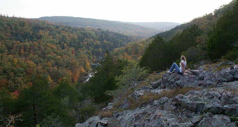
Overlooking Marble creek in St. Francois Mountains. Photo by ARPwildlifebio wiki.

Sam A. Baker state park dining lodge. Photo by Kbh3rd wiki.
Location: In Sam A. Baker State Park
- States: Missouri
- Counties: Wayne
Mudlick Trail provides an intimate journey into one of the oldest mountain regions of North America: the St. Francois Mountains. It is a moderate to very strenuous 12-mile loop trail, climbing from 415 feet above sea level in Big Creek Valley to 1,313 feet above sea level at the top of Mudlick Mountain. It is open to hiking, backpacking, and equestrian use. Most of the trail is located in the Mudlick Mountain Wild Area, one of the most significant, undisturbed natural landscapes in Missouri.
The trail begins by ascending the bluffs above Big Creek where three stone hiking shelters, constructed by the Civilian Conservation Corps in the 1930s, offer outstanding views of the surrounding countryside and the "shut-ins" valley below. The trail then drops into Mudlick Hollow, a narrow rock-strewn valley interspersed with pools of clear water. The trail follows Mudlick Hollow for about three-fourths of a mile before beginning a gradual climb to the summit of Green Mountain. Horses may bypass the rocky Mudlick Hollow on the horse-friendly Hollow Pass Trail. Hikers may use the Hollow Pass Trail as a return route after visiting the scenic hollow. The view from Green Mountain is best during the fall and winter when the trees in the thick oak-hickory forest have shed their leaves. From the southern end of Green Mountain, the trail descends rapidly, via a series of"switchbacks," into Logan Creek Valley. A dense stand of red cedar grows in the valley, providing a cool shaded corridor for the trail. Once through the valley, the trail begins a steady climb to the top of Mudlick Mountain. It then traverses the rugged eastern slope of the mountain back to the starting point.
The surrounding conical, domelike hills of the St. Francois Mountains and the distinctive 1930s craftsmanship of the Civilian Conservation Corps characterize the more than 5,000-acre park. Big Creek and the St. Francois River attract anglers who cast for smallmouth bass, crappie, sunfish, goggle-eye, and catfish. Water enthusiasts enjoy wading, tubing, swimming, and snorkeling in the cool, clear waters. Canoeing is offered year-round on the St. Francois River while the best time to float Big Creek is in the spring or early summer when kayaks are often used.
Accessibility Information
No text provided.
Allowed Uses:
Swimming Dogs, on leash Equestrian Hiking/WalkingOther Activities
- Camping
- Wildlife viewing / observation
Public Contact
Don PhiferMissouri Dept of Natural Resources
Division of State Parks
Jefferson City, MO 65063
[email protected] • (573) 751-2479
Contact the trail manager for current maps and visiting details.
More Details
- Elevation (low): --
- Elevation (high): --
- Elevation (cumulative): --
- Part of a Trail System? No
- Surface (primary): --
- Surfaces (additional): --
- Tread Width (average): 18"
- Tread Width (minimum): --
- Running length (minimum): --
- Tread Grade (average, percent): --
- Tread Grade (maximum):
- Running length (maximum): --
- Cross-slope (average, percent): --
- Cross-slope (maximum): --
- Running length (maximum): --
- Certified as an NRT
Oct 8, 1980

