Natural Bridge Trail
check with the trail manager for updated details before visiting.
Natural Bridge Trail
State
Backcountry Trail
- Length
0.5 miles
- Elevation Gain
--
- Route Type
out & back
- Length
0.5 miles - Elevation Gain
-- - Route Type
out & back
This trail was built in the 1890's by the Lexington and Eastern Railroad. It is the most popular trail for hiking to the Natural Bridge.

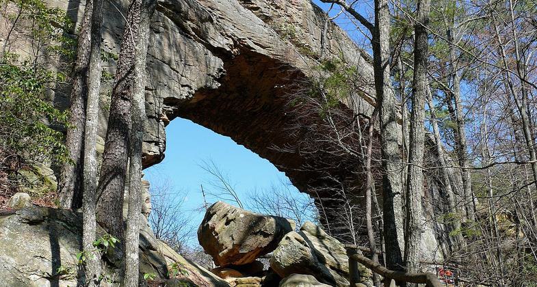
Looking up from beneath the bridge. Photo by Ken Thomas/wiki.

Photo by Joelle Moorhead.

Photo from below the Natural Bridge. Photo by ChrisKuehl/wiki.
Location: Near Slade, Kentucky.
- States: Kentucky
Beginning near the gift shop, the trail gently climbs .25 miles to the trailhead behind Hemlock Lodge. From here, you will see the steepest part of the trail before you, but at the top of the limestone steps it levels off. There are five trail shelters along this trail, three of which were built by the Civilian Conservation Corps during the 1930s. The trail climbs over 400 feet through an impressive forest of hemlock, tulip trees, white pine, and thickets of rhododendron. It ends beneath the span of the Natural Bridge. Access to the top of the bridge is through a natural fracture on the other side of the arch. Elevation change of 420 feet.
Accessibility Information
No text provided.
Allowed Uses:
Hiking/WalkingPublic Contact
Kentucky Dept. of Parks1108 Capitol Plaza
Frankfort, KY 40601
Contact the trail manager for current maps and visiting details.
More Details
- Elevation (low): --
- Elevation (high): --
- Elevation (cumulative): --
- Part of a Trail System? No
- Surface (primary): --
- Surfaces (additional): --
- Tread Width (average): 0"
- Tread Width (minimum): --
- Running length (minimum): --
- Tread Grade (average, percent): --
- Tread Grade (maximum):
- Running length (maximum): --
- Cross-slope (average, percent): --
- Cross-slope (maximum): --
- Running length (maximum): --
- Certified as an NRT
Nov 29, 1983

