Nature Coast State Trail
check with the trail manager for updated details before visiting.
Nature Coast State Trail
State
Rail Trail
- Length
31.7 miles
- Elevation Gain
--
- Route Type
out & back
- Length
31.7 miles - Elevation Gain
-- - Route Type
out & back
Traversing Florida's Nature Coast Region through the Suwannee River Valley, the 31.7-mile long Nature Coast State Trail, managed by the Florida Park Service, consists of two primary alignments. Built along abandoned rail lines that intersect at Wilcox Junction, the trail connects the communities of Cross City, Trenton, Fanning Springs and Chiefland. Among the trail's highlights is an historic railroad trestle crossing the Suwannee River.

Location: The rail trail is located in the Nature Coast Region of Florida. West of Gainesville, the trail connects the communities. Rail trail connecting Cross City east to Trenton and Chiefland.
- States: Florida
- Counties: Dixie, Gilchrist, Levy
- Cities/Townships: Chiefland, Fanning Springs, Cross City, Trenton
Traversing Florida's Nature Coast Region through the Suwannee River Valley, the 31.7-mile-long Nature Coast State Trail, managed by the Florida Park Service, consists of two primary alignments. Built along abandoned rail lines that intersect at Wilcox Junction, the trail connects the communities of Cross City, Trenton, Fanning Springs, and Chiefland. Among the trail's highlights is a historic railroad trestle crossing the Suwannee River.
The property was acquired from CSX Transportation, Inc. in 1996 by the Office of Greenways and Trails Acquisition Program, a component of Florida Forever. The Florida Board of Trustees of the Internal Improvement Trust Fund holds fee simple title to the property. The property is leased to the park service through April 29, 2048. Development for the paving of the trail was funded by the Florida Department of Transportation.
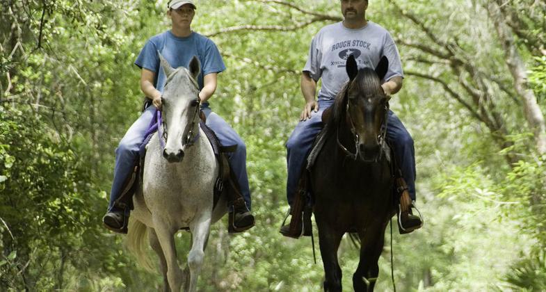
Occupying a former CSX railroad right-of-way, most of the trail parallels US 19 and State Road 26 and is embedded in an agricultural landscape. Trailheads are located within the five linked rural communities, making the trail easily accessible for local use, in addition to being close to accommodations, restaurants, and other recreational opportunities. The Nature Coast State Trail provides a scenic experience for runners, walkers, bikers, and skaters. Equestrian riders can enjoy trails that parallel some portions of the paved trail. Currently, parking for equestrians can be found at the Fanning Springs and Old Town trailheads.
Several significant land and water resources exist in the vicinity of the Nature Coast State Trail. They include Suwannee River, Fanning Springs, Big Bend Seagrasses Aquatic Preserve, Manatee Springs State Park, City of Hawkinsville Underwater Archaeological Preserve, Andrews Wildlife Management Area, Cedar Key Scrub State Reserve, Waccasassa Bay State Preserve, Cedar Keys National Wildlife Refuge, Lower Suwannee National Wildlife Refuge, Jena Wildlife Management Area, Gulf Hammock Wildlife Management Area, and Goethe State Forest. Other public lands are found to the west and south of the Nature Coast State Trail including the Fanning Springs State Recreation Area, Manatee Springs State Park, and Andrews Wildlife Management Area. Between Trenton and Cross City, to the north of Fanning Springs, the trail crosses the Suwannee River Wilderness Trail.
Accessibility Information
No text provided.
Allowed Uses:
Bicycling Dogs, on leash Hiking/WalkingPublic Contact
Kirk MarhefkaFlorida Park Service
18020 NW Highway 19
Fanning Springs, FL 32693
[email protected] • (352) 535-5181
www.floridastateparks.org/parks-and-trails/nature-coast-state-trail
Contact the trail manager for current maps and visiting details.
More Details
- Elevation (low): 10
- Elevation (high): 50
- Elevation (cumulative): --
- Part of a Trail System? No
- Surface (primary): Paved
- Surfaces (additional): Grass or Vegetation
- Tread Width (average): 127"
- Tread Width (minimum): --
- Running length (minimum): --
- Tread Grade (average, percent): --
- Tread Grade (maximum):
- Running length (maximum): --
- Cross-slope (average, percent): --
- Cross-slope (maximum): --
- Running length (maximum): --
- Certified as an NRT
May 2, 2010