Neal Smith Trail
check with the trail manager for updated details before visiting.
Neal Smith Trail
City, Town, or County
Frontcountry Trail
Urban Trail
- Length
24.7 miles
- Elevation Gain
--
- Route Type
out & back
- Length
24.7 miles - Elevation Gain
-- - Route Type
out & back
The designated 13 miles of National Recreation Trail managed by the Corps of Engineers is an internal section of 26 miles, which extends from Des Moines to Big Creek State Park. The Neal Smith Trail has many access points within the parks to allow cyclists a trip that will meet their needs. The bike trail also is an excellent area to rollerblade, walk, or run in the summer months and cross country ski or snow shoe in the winter months. The trail winds its way down through the Des Moines river valley all the way to the Botanical Center, providing one of the most scenic routes within Polk County Iowa.

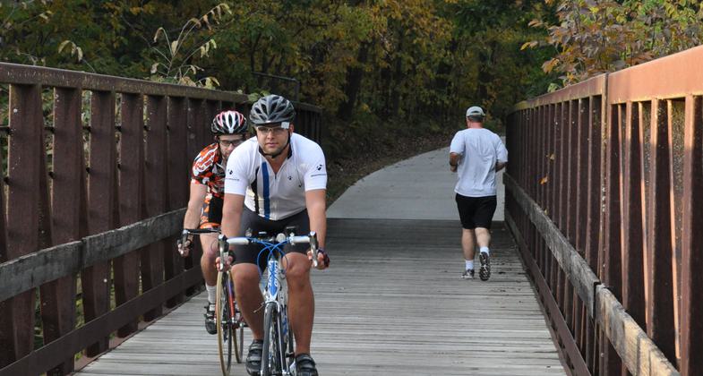
Bicyclists and joggers crossing a bridge on the Neal Smith Trail. Photo by Dayne Magneson.

Location: Saylorville Lake to Des Moines
- States: Iowa
- Counties: Polk
- Cities/Townships: Des Moines
The designated 13 miles of National Recreation Trail managed by the Corps of Engineers is an internal section of 26 miles, which extends from Des Moines to Big Creek State Park. The Neal Smith Trail has many access points within the parks to allow cyclists a trip that will meet their needs. The bike trail also is an excellent area to rollerblade, walk, or run in the summer months and cross-country ski or snowshoe in the winter months. The trail winds its way down through the Des Moines River valley all the way to the Botanical Center, providing one of the most scenic routes within Polk County Iowa.
Originally constructed in 1982, the Neal Smith Trail is one of the oldest trails in the Central Iowa Trail Network. It extends 24.7 miles between downtown Des Moines and Big Creek State Park - establishing the Central Iowa connection of the American Discovery Trail. As the asphalt trail crosses different jurisdictions, it is managed in part by the City of Des Moines, the Iowa Department of Natural Resources, and the Army Corps of Engineers. The trail is available for non-motorized users including bicyclists and pedestrians.
The route in Des Moines begins at a connection with the John Pat Dorrian Trail downtown, just under University Avenue. It follows the east side of the Des Moines River north to Birdland Marina and Park and on through the Ding Darling Greenway, which is a large, scenic wooded area. There are approximately 260 acres of the wooded area adjacent to this segment of the trail, as well as 17 acres in McHenry Park that is accessible to Neal Smith Trail users via a half-mile trail connection. The Neal Smith Trail also connects to the InterUrban Trail, which crosses the Des Moines River via a former historic railroad bridge and continues west to Beaverdale Park. The trail safely passes under Euclid Avenue with connections up to the street on both the north and south sides.
Further north, the Neal Smith Trail wanders through Army Corps-managed campgrounds, picnic areas, and fishing spots along the Des Moines River. There are restrooms and bike rentals nearby. The trail also features a butterfly garden with resident and migrating butterflies, yellow-headed coneflowers, zinnias, and butterfly bushes. Natural Oak Savannah, wetlands, and a 709-acre prairie bring visitors back to the natural state of Iowa.
Accessibility Information
No text provided.
Allowed Uses:
Bicycling Hiking/Walking Snow, cross-country skiing Snow, snowshoeingOther Activities
- Snow, snow play general
Public Contact
City of Des Moines Parks and Recreation3226 University Avenue
Des Moines, IA 50311
[email protected] • (515) 237-1386
Contact the trail manager for current maps and visiting details.
More Details
- Elevation (low): 778
- Elevation (high): --
- Elevation (cumulative): --
- Part of a Trail System? No
- National Designations: National Recreational Trail
- Surface (primary): Paved
- Surfaces (additional): Paved
- Tread Width (average): 96"
- Tread Width (minimum): --
- Running length (minimum): --
- Tread Grade (average, percent): --
- Tread Grade (maximum):
- Running length (maximum): --
- Cross-slope (average, percent): --
- Cross-slope (maximum): --
- Running length (maximum): --
- Certified as an NRT
Nov 15, 1990

