North Central State Trail
check with the trail manager for updated details before visiting.
North Central State Trail
State
Rail Trail
- Length
62 miles
- Elevation Gain
--
- Route Type
out & back
- Length
62 miles - Elevation Gain
-- - Route Type
out & back
The North Central State Trail is a 62-mile multi-use rail trail connecting the northern Michigan communities of Gaylord, Vanderbilt, Wolverine, Indian River, Topinabee, Cheboygan, and Mackinaw City. The trail has a 10 feet wide packed crushed limestone surface and is open to all non-motorized users year-round and snowmobiles from December 1 to March 31.
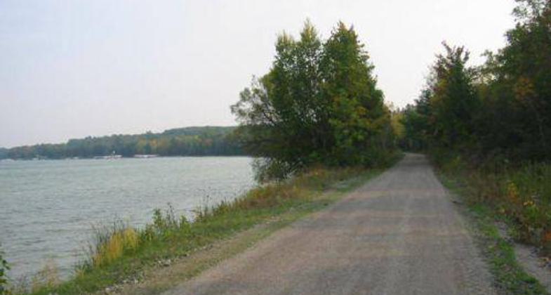
Views of Mullett Lake along the North Central State Trail. Photo by Emily Meyerson

Cheboygan Trailhead

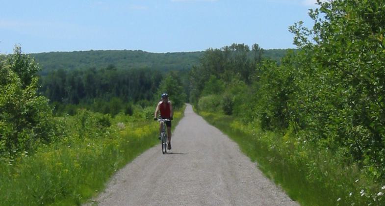
Family Bike Ride along Mullett Lake

Kayakers seen from a bridge on the NCST

Topinabee Depot

Lone Rider near Stewart's Creek Marsh

Bike Riders on NCST
Location: A 62 mile rail trail that connects Gaylord, Michigan to Mackinaw City, Michigan.
- States: Michigan
- Counties: Otsego, Cheboygan
- Cities/Townships: Gaylord, Cheboygan, Vanderbilt, Wolverine, Mackinaw City and 11 Townships.
The North Central State Trail (NCST) is a 62-mile multi-use rail trail managed by the Michigan Department of Natural Resources and endorsed by the Top of Michigan Trails Council, the Friends of the North Central State Trail, and the communities the trail goes through. The trail surface is packed crushed limestone which is excellent for most non-motorized uses as well as snowmobiles in the winter months. The NCST was the northern segment of the Michigan Central Railroad built in the late 1800s.
The terrain and the communities the trail passes through are unique and varied; it goes through rural agricultural areas, Mackinaw State Forest lands, along the Sturgeon River, the shore of Mullett Lake, and parallel to the Straits of Mackinaw. The unique trail segments are described from south to north.
Gaylord to Vanderbilt is 7.6 miles and goes through beautiful rolling farmlands with great rural views. The trail passes through two tunnels before it gets to the Village of Vanderbilt. The City of Gaylord, known as the Alpine Village, has all modern conveniences and facilities. The Village of Vanderbilt, the gateway to Pigeon River County, has a store and restaurants.
Vanderbilt to Wolverine is 10.9 miles and has the most remote section of trail, there are no access points or development for four miles. The trail goes through the Stewart's Creek Marsh where there are excellent wildlife and birding opportunities including elk and bear sitings. The trail crosses the Sturgeon River three times before it gets to the Village of Wolverine's Riverside Park. The Village of Wolverine has stores and restaurants as well as a canoe livery.
Wolverine to Indian River is 9.6 miles and runs along and across the Sturgeon River. There are many river access sites, views, and great fishing opportunities. The trail goes through Haakwood State Forest Campground, Rondo Canoe Access Site, and is about a mile from Burt Lake State Park. Multi-sport fun combining river and trail activities is possible. The town of Indian River, on the Historic Inland Waterway, has a modern trailhead, grocery store, hotels and restaurants, bike rental, canoe livery, and ice cream shops.
Indian River to Topinabee is 5.6 miles. The trail crosses the Indian River and runs along Mullett Lake through forest lands and resort communities. The small community of Topinabee, on the shore of Mullett Lake, has a historic depot and lakeside park. There is cabin rental, restaurants, and a store.
Topinabee to Cheboygan is 12.2 miles. The first 6.6 runs along the blue-green waters of Mullett Lake. Spectacular views and water access are available between the various developed resort associations. At the north end of the lake, the trail turns due north to the City of Cheboygan through rural farmlands. In Cheboygan, there is a modern trailhead facility and a picnic pavilion. Downtown Cheboygan, with wonderful parks, a Lake Huron beach, riverside restaurants, shops, hotels, and a local brewery await a tired trail user. At the Cheboygan Trailhead, there is a connection to the 71-mile North Eastern State Trail, which runs southeast to the City of Alpena.
Cheboygan to Mackinaw City is 16.3 miles. The trail goes through varied types of forest lands and runs parallel to US-23 and the Straits of Mackinac. The trail runs right through Mill Creek Historic State Park and has access to a wonderful roadside park with excellent views of the Mackinaw Bridge. The trail terminus is at a modern trailhead facility in the Village of Mackinaw City with a beautiful stone pavilion. The trail within the Village has a paved 12' wide asphalt surface. Hotels, shops, restaurants, historic sites, lighthouses, and parks await the visitor in fun-filled Mackinaw City. At the Mackinaw Trailhead, a trail user can also head southwest on the North Western State Trail (currently undeveloped) to the City of Petoskey. In Mackinaw City, a trail user can catch a ferry to historic Mackinac Island where no motorized vehicles are allowed, an experience that should not be missed.
Accessibility Information
No text provided.
Allowed Uses:
Bicycling Dogs, on leash Equestrian Hiking/Walking Motorized vehicles, snowmobiling Snow, cross-country skiing Snow, snowshoeingOther Activities
- Fishing
- Snow, snow play general
- Wildlife viewing / observation
Public Contact
James RadabaughMichigan Department of Natural Resources
PO Box 30452
Lansing, MI 48909
[email protected] • 517-373-1276
Contact the trail manager for current maps and visiting details.
More Details
- Elevation (low): 1450
- Elevation (high): 550
- Elevation (cumulative): --
- Part of a Trail System? No
- State Designations: 2011 MI Trails and Greenways Trail of the Year
- Surface (primary): Rock, crushed
- Surfaces (additional): Snow or ice
- Tread Width (average): 120"
- Tread Width (minimum): 120
- Running length (minimum): --
- Tread Grade (average, percent): 2
- Tread Grade (maximum): 5
- Running length (maximum): --
- Cross-slope (average, percent): 2
- Cross-slope (maximum): --
- Running length (maximum): --
- Certified as an NRT
May 29, 2012