North Kaibab Trail
check with the trail manager for updated details before visiting.
North Kaibab Trail
National Park Service
Backcountry Trail
- Length
14.2 miles
- Elevation Gain
--
- Route Type
out & back
- Length
14.2 miles - Elevation Gain
-- - Route Type
out & back
The North Kaibab Trail is the least visited but most difficult of the three maintained trails at Grand Canyon National Park.
Location: At Grand Canyon Nat. Park, links North Rim Visitor Ctr. down to Colorado R.
- States: Arizona
- Counties: Coconino
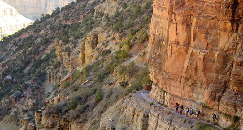
Resembling the Bright Angel Trail more than the South Kaibab Trail, the North Kaibab initially descends steeply down the head of a valley via a series of numerous switchbacks. After the lush verdancy and impressive views below the trailhead, the trail reaches the distinctive Supai Tunnel, where hikers will find potable water (mid-May to mid-October) and pit toilets, but no emergency phone. Switchbacks continue to the massive cliffs of Redwall Limestone, where for long stretches the trail has been blasted out of the cliff in a half tunnel. The Redwall section is awe-inspiring in every way; fantastic exposure and views mingle with a reminiscence of an age when engineering marvels were commonplace.
Where the bulk of the trail's descent meets the flatter bottom of Bright Angel Canyon, Roaring Springs is a worthwhile side trip. Here, water gushes forth directly out of the cliffs, cascading over moss and fern to form Bright Angel Creek (which will be a constant companion all the way to the Colorado River). This giant spring provides drinking water for every visitor and resident within Grand Canyon National Park. The water is delivered to the South Rim via a pipeline buried beneath the North Kaibab Trail (installed 1965-1970). You can see this amazing pipeline as it stretches across the Colorado River on the underside of the Bright Angel Trail's Silver Bridge.
At mile 5.4 an unexpected house comes into view. The Pumphouse Residence, also known as the Aiken Residence is where artist and park employee Bruce Aiken lived and painted for decades. In years past the lucky hiker could get a refreshing cup of lemonade from one of the Aiken kids who were raised at the bottom of the Grand Canyon. Passing the Pumphouse Residence is a welcome sign for the descending backpacker for it signals the approach of Cottonwood Campground. Those fortunate to overnight at Cottonwood Campground will have the time to explore a beautiful oasis located 1.6 miles down-creek from the campground: Ribbon Falls is a true gem of the North Kaibab Trail. The waterfall is located in a grotto on the west side of Bright Angel Creek, so reaching it is a short but extremely rewarding side trip. Hikers caught in the heat of the day should consider taking a siesta here from 10 a.m. to 4 p.m.
Between Cottonwood Campground and Bright Angel Campground, the trail enters the Inner Gorge, a narrow canyon within the canyon where the trail is boxed in on either side by 1.7 billion-year-old Vishnu Schist (the contact between the top of the Vishnu Schist and the overlying Tapeats Sandstone marks the Great Unconformity where over 1 billion years of geology is missing). Though the trail here is not challenging from the perspective of elevation profile, be aware that this is a particularly dangerous stretch of trail during the summer months. Because the entire 7.2-mile stretch is at a low elevation, it becomes extremely hot from early morning to late afternoon. The gorge of black rock through which the trail passes becomes like an oven and can be compared to walking through a parking lot in Phoenix or Las Vegas in the summertime. Always plan on reaching Bright Angel Campground before ten in the morning.
Accessibility Information
No text provided.
Allowed Uses:
Equestrian Hiking/WalkingPublic Contact
Grand Canyon National ParkP.O. Box 129
Grand Canyon, AZ 86023
(520) 638-9734 ext. 2
Contact the trail manager for current maps and visiting details.
More Details
- Elevation (low): --
- Elevation (high): --
- Elevation (cumulative): --
- Part of a Trail System? No
- Surface (primary): --
- Surfaces (additional): --
- Tread Width (average): 48"
- Tread Width (minimum): --
- Running length (minimum): --
- Tread Grade (average, percent): --
- Tread Grade (maximum):
- Running length (maximum): --
- Cross-slope (average, percent): --
- Cross-slope (maximum): --
- Running length (maximum): --
- Certified as an NRT
Feb 19, 1981


