North Mountain Trail
check with the trail manager for updated details before visiting.
North Mountain Trail
City, Town, or County
Backcountry Trail
- Length
0.9 miles
- Elevation Gain
--
- Route Type
out & back
(1 review)
- Length
0.9 miles - Elevation Gain
-- - Route Type
out & back

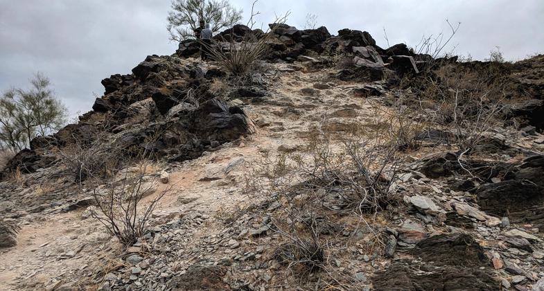
North Mountain - typical section of trail. Photo by Jim Walla.

North Mountain - view of Phoenix from the peak. Photo by Jim Walla.

North Mountain - typical section of trail. Photo by Jim Walla.

North Mountain - typical section of trail. Photo by Jim Walla.

North Mountain - typical section of trail. Photo by Jim Walla.

North Mountain - peak is marked with a black arrow. Trail is clearly visible going up the mountain. Photo by Jim Walla.
Location: In Phoenix, in North Mountain Park, near 7th and Dunlap Sts.
- States: Arizona
The trail up North Mountain is called the National Trail. The full trail is a loop that goes up one side of the mountain and down the other. One side of the trail is closed and is being widened into a road. However, you can still hike the other side as an out-and-back.
The trail is relatively short (about 1.3 miles RT). It is also steep, about 700 feet. One section had an average gradient of about 27% for 0.3 miles, so even given its short length, it was a fairly tough hike. The trail condition was not great. In a lot of spots, there are small stones which makes it a little slippery coming down (these can be seen in some of the pictures posted). I would definitely wear good boots and I am glad I brought my poles. Because of the trail condition, I would call the trail moderate to difficult.
Accessibility Information
No text provided.
Reviews
Jim Walla
North Mountain National Trail - February 12, 2018
The trail up North Mountain is called the National Trail. The full trail is a loop that goes up on side of the mountain and down the other. One side of the trail is closed and is being widened into a road. However, you can still hike the other side as an out and back. The trail is relatively short (about 1.3 miles RT). It is also steep, about 700 feet. One section had a average gradient of about 27% for 0.3 miles, so even given its short length, it was a fairly tough hike. Trail condition was not great. In a lot of spots there are small stones which makes it a little slippery coming down (these can be seen in some of the pictures I posted). I would definitely wear good boots and I am glad I brought my poles. Because of the trail condition, I would call the trail"moderate to difficult". Views from the top were quite good. Too bad about the part being paved, but it is still a worthwhile hike as an out and back.
Allowed Uses:
Hiking/WalkingPublic Contact
Jeff SpellmanPhoenix Parks and Recreation Department
17642 North 40th St.
Phoenix, AZ 85032
[email protected] • (602) 262-7901
Contact the trail manager for current maps and visiting details.
More Details
- Elevation (low): --
- Elevation (high): --
- Elevation (cumulative): --
- Part of a Trail System? No
- Surface (primary): --
- Surfaces (additional): --
- Tread Width (average): 0"
- Tread Width (minimum): --
- Running length (minimum): --
- Tread Grade (average, percent): --
- Tread Grade (maximum):
- Running length (maximum): --
- Cross-slope (average, percent): --
- Cross-slope (maximum): --
- Running length (maximum): --
- Certified as an NRT
Jan 6, 1974

