North Umpqua Trail - Maidu Lake Segment
check with the trail manager for updated details before visiting.
North Umpqua Trail - Maidu Lake Segment
USDA Forest Service
Backcountry Trail
- Length
9 miles
- Elevation Gain
--
- Route Type
out & back
- Length
9 miles - Elevation Gain
-- - Route Type
out & back

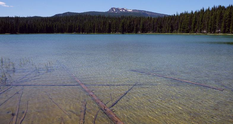
Maidu Lake (the source of the North Umpqua River) in the Cascade Range. Photo by Rick Swart/ODFW.
Location: Diamond Lake Ranger District, Umpqua National Forest.
- States: Oregon
- Counties: Douglas, Klamath
The first mile of trail from Kelsay Valley Trailhead follows the river as it meanders through a broad, grassy flat. At 2.7 miles, near the Tolo Creek Trail #1466 junction the trail enters Mt. Thielsen Wilderness (this segment is closed to mountain bike use). As the trail climbs toward Lake Lucile and Maidu Lake, you will travel over deep deposits of pumice deposited over 7,700 years ago by the eruption of Mt. Mazama that created Crater Lake. Both of these High Cascades lakes are often stocked with fingerling trout. Lake Lucile covers 9 acres and averages a depth of 15 feet. Maidu Lake, the source of the North Umpqua River, averages a depth of 12 feet and covers 20 acres.
From Maidu Lake, Kelsay Valley Trailhead is 9 miles to the west and Digit Point Trailhead is 4.75 miles to the east at Miller Lake in Fremont-Winema National Forest.
The Pacific Crest National Scenic Trail #2000 junction with North Umpqua Trail is about one-mile southeast of Maidu Lake.
Be prepared for hordes of mosquitoes during the late spring and early summer months.
Accessibility Information
No text provided.
Allowed Uses:
Dogs, on leash Equestrian Hiking/Walking Snow, cross-country skiing Snow, snowshoeingOther Activities
- Camping
- Fishing
- Snow, snow play general
Public Contact
Michael KinneyUmpqua National Forest
Diamond Lake Ranger District
Idleyld Park, OR 97447
[email protected] • (541) 498-2531
www.fs.fed.us/r6/umpqua
Contact the trail manager for current maps and visiting details.
More Details
- Elevation (low): 4260
- Elevation (high): 6240
- Elevation (cumulative): --
- Part of a Trail System? No
- Surface (primary): Soil
- Surfaces (additional): Soil
- Tread Width (average): 36"
- Tread Width (minimum): --
- Running length (minimum): --
- Tread Grade (average, percent): 4
- Tread Grade (maximum): 10
- Running length (maximum): --
- Cross-slope (average, percent): --
- Cross-slope (maximum): --
- Running length (maximum): --
- Certified as an NRT
Jul 18, 1983

