North Western State Trail
check with the trail manager for updated details before visiting.
North Western State Trail
State
Rail Trail
- Length
32 miles
- Elevation Gain
--
- Route Type
out & back
- Length
32 miles - Elevation Gain
-- - Route Type
out & back
The 32 mile North Western State Trail connects the resort communities of Petoskey, Harbor Springs, Alanson, Pellston, and Mackinaw City in northern Michigan. The trail is a 10' wide universally accessible surface with both asphalt and limestone. It is open year-round to non-motorized users and for snowmobiles from December 1 to March 31 each year.

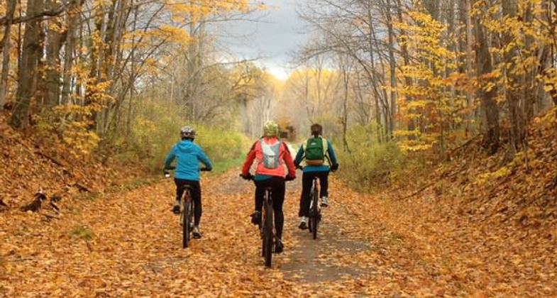
Fall Color on the North Western State Trail. Photo by Emily Meyerson

The North Western State Trail passes over the Carp Lake River in Northern Michigan. Photo by Eric Cox.

Fall foliage blooms vividly along the North Western State Trail near Levering, Mich. Photo by Eric Cox.

Carp Lake River Bridge

Trail users at the Oden Fisheries Visitor Center

Maple River Bridge
Location: Rail Trail that connects Petoskey to Mackinaw City in the Northern Lower Peninsula of Michigan.
- States: Michigan
- Counties: Emmet
- Cities/Townships: Bear Creek, Little Traverse, Alanson, Littlefield, Maple River, Pellston, McKinley, Carp Lake, Wawatam, Mackinaw City
The North Western State Trail (NWST) is 32 miles in length and connects all the incorporated communities of Emmet County including Petoskey, Harbor Springs, Alanson, Pellston, and Mackinaw City. But not only does the trail link the communities of Emmet County where it is located, but helps to connect the entire 250+ mile Northern Lower Peninsula Trail Network. With the completion of the NWST, a trail user can now start in Alpena at Lake Huron and get to Lake Michigan in Charlevoix (140 miles) entirely on the trail; completing a Great Lake to Great Lake adventure.
Most of the NWST is located on the former Grand Rapids and Indiana lines of the Pennsylvania Railroad that ran between Grand Rapids and Mackinaw City from 1882 to 1961. Michigan Northern Railway operated the line until 1987. With the extensive resort and tourist-based economy of the region, the rail line was nicknamed the fishing line.
Michigan Bell donated the northern 23 miles to the Michigan Department of Natural Resources (DNR) in 1989 and the DNR purchased the southern 5 miles in 2001. In other areas easements were obtained or agreements with local and state road agencies allowed for the trail in road rights of way.
DNR, in partnership with Mackinaw City, developed the northern 1.5 miles of trail with a 10' wide asphalt surface in 2011. Emmet County then moved ahead in partnership with the DNR to develop the 7.5 southern miles with a 10' wide asphalt surface from Petoskey to Alanson in 2013. And in 2015 DNR and the Michigan Department of Transportation (MDOT) worked in partnership to develop 23 miles from Alanson to Mackinaw City with a 10' wide limestone surface. The trail improvements increase the facility's accessibility and meet and exceed the requirements of the Americans with Disabilities Act.
The southern end of the trail starts (or ends) at Spring Lake Park where there is parking, bathrooms, a picnic area, and a boardwalk trail. At this location, the trail connects to the 26 miles of Little Traverse Wheelway with direct connections to the Cities of Petoskey and Harbor Springs. On the north end, the trail ends (or begins) at the Mackinaw City Trailhead where there are bathrooms, parking, and a picnic area. At this location, the trail connects with the North Central State Trail, which is a designated National Recreation Trail. The Village of Pellston currently has plans to develop a year-round trailhead facility with parking and bathrooms; other trailside amenities are located in Conway and Oden.
The trail is an excellent recreation resource as it connects people to natural and historic resources. The trail runs along Spring, Mud, and Round lakes, through wetlands and forest lands, and across three scenic bridges over the Oden Creek, Maple River, and the Carp Lake River. It connects to Lake Michigan and its sand dunes at Petoskey State Park, scenic wetland boardwalk trail at Spring Lake Park, Hiawatha Pageant Michigan Historic Marker on Round Lake, interpretive trails at the Oden Fisheries Visitor Center, the Inland Waterway Museum in Alanson, the Pellston Historic Museum and lighthouses and museums in Mackinaw City. In Mackinaw City, you can catch a ferry to the historic and carless Mackinac Island, a must-see Michigan attraction.
The trail segment Between Alanson to Mackinaw City is also a designed snowmobile trail and is groomed for that use between December 1 and March 31 each year. The trail corridor runs parallel to US-31 and it serves as a non-motorized transportation facility for the community. Mackinaw City, Emmet County, Harbor Springs Snowmobile Club, and the DNR continue to manage and maintain the trail.
Accessibility Information
No text provided.
Allowed Uses:
Bicycling Dogs, on leash Equestrian Hiking/Walking Motorized vehicles, snowmobiling Snow, cross-country skiing Snow, snowshoeingOther Activities
- Heritage and history
- Snow, snow play general
- Wildlife viewing / observation
Public Contact
Emily MeyersonMichigan Department of Natural Resources
2475 M-119
Petoskey, MI 49770
[email protected] • 231-347-4899
Contact the trail manager for current maps and visiting details.
More Details
- Elevation (low): 603
- Elevation (high): 760
- Elevation (cumulative): --
- Part of a Trail System? No
- National Designations: North Country National Scenic Trail (part)
- State Designations: Iron Belle Trail (part)
- Surface (primary): Rock, crushed
- Surfaces (additional): Paved
- Tread Width (average): 120"
- Tread Width (minimum): 120
- Running length (minimum): --
- Tread Grade (average, percent): 1
- Tread Grade (maximum): 2
- Running length (maximum): --
- Cross-slope (average, percent): 1
- Cross-slope (maximum): --
- Running length (maximum): --
- Certified as an NRT
May 16, 2018

