Ohio & Erie Canal Towpath Trail
check with the trail manager for updated details before visiting.
Ohio & Erie Canal Towpath Trail
National Park Service
Backcountry Trail
Frontcountry Trail
Urban Trail
- Length
94 miles
- Elevation Gain
--
- Route Type
out & back
- Length
94 miles - Elevation Gain
-- - Route Type
out & back
The Ohio & Erie Canal Towpath Trail is a 60-mile multi-use trail that provides recreational use within three counties in Ohio. The Towpath Trail travels through metropolitan cities, local villages, regional Metroparks and the Cuyahoga Valley National Park.

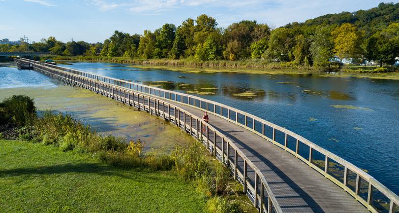
Floating Towpath. Photo by Tim Fitzwater.

Heronry. Photo by Anthony Boarman.

Towpath in Cleveland. Photo by Canalway Partners.

Tuscarawas River, Dover Dam. Photo by Tom Jones.

Canal Boat, Canal Fulton. Photo by Tim Fitzwater.

Bald Eagle. Photo by Kyle Lanzer.

Industrial Relics. Photo by Mary Shaw.

The iconic Ohio & Erie Canal Towpath Trail, an 80+ spine connecting Cleveland to central OH. Photo by Kyle Lanzer.

The iconic Ohio & Erie Canal Towpath Trail, an 80+ spine connecting Cleveland to central OH. Photo by Kyle Lanzer.
Location: The Towpath Trail begins in Cleveland, north of Harvard Road, travels, through Cleveland Metroparks, Cuyahoga Valley National Park, Metroparks, Serving Summit County, through the remainder of Summit County, and ends in Tuscarawas County.
- States: Ohio
- Counties: Cuyahoga, Summit, Tuscarawas
- Cities/Townships: Cleveland, Akron, Zoarville, multiple jurisdictions
With 94 contiguous miles of trail and 56 trailhead parking lots, the Towpath Trail offers adventures of any distance and difficulty within the Ohio & Erie Canalway National Heritage Area. The trail goes through cities such as Cleveland and Akron and smaller rural areas in Stark and Tuscarawas Counties. 18 miles of the Towpath Trail are in the scenic Cuyahoga Valley National Park. The section of trail in Stark County is named in honor of Congressman Ralph Regula, an Ohio Congressman who was instrumental in getting the Towpath Trail built and designating the National Heritage Area.
The Towpath Trail features historical 19th-century lock remnants and plenty of educational panels about the history and nature of Ohio. Select overnight parking is available and there are some campsites and other accommodations for a multiday trip. Trail surfaces vary from paved to crushed limestone and restaurants and visitor centers are available at points along the trail. Tired of pedaling? The Cuyahoga Valley Scenic Railroad will take you and your bike up and down the length of Cuyahoga Valley National Park.
For more details on what to do along the Towpath Trail, see, https://www.ohioanderiecanalwa...
Accessibility Information
No text provided.
Allowed Uses:
Bicycling Dogs, on leash Hiking/Walking Snow, cross-country skiing Snow, snowshoeingOther Activities
- Snow, snow play general
- Wildlife viewing / observation
Public Contact
Cuyahoga ValleyNational Recreation Area
Brecksville, OH 44141
Contact the trail manager for current maps and visiting details.
More Details
- Elevation (low): --
- Elevation (high): --
- Elevation (cumulative): --
- Part of a Trail System? No
- Surface (primary): --
- Surfaces (additional): --
- Tread Width (average): 72"
- Tread Width (minimum): --
- Running length (minimum): --
- Tread Grade (average, percent): 2
- Tread Grade (maximum):
- Running length (maximum): --
- Cross-slope (average, percent): --
- Cross-slope (maximum): --
- Running length (maximum): --
- Certified as an NRT
May 31, 1977


