Outlet Campground Trail System
check with the trail manager for updated details before visiting.
Outlet Campground Trail System
U.S. Corps of Engineers
Backcountry Trail
Urban Trail
- Length
3.25 miles
- Elevation Gain
--
- Route Type
Loop
- Length
3.25 miles - Elevation Gain
-- - Route Type
Loop
The Outlet Campground Trail System is composed of three individual trails intertwined to provide a little over three miles of outdoor recreational trails to campers as well as the community of Osage County. This trail system provides a half-mile of paved surface accessible to the physically challenged in addition to another two and a half miles of compacted soil and gravel trail.

Outlet Campground Trail System Trailhead 1. Photo by Gina Pate

River Pond Trail at boat ramp

River Bottom Nature Trail

River Bottom Nature Trail--Outlet Campground Trail System Trailhead 3

River Bottom Nature Trail-Outlet Campground Trail System Trailhead 2

Outlet Campground Trail System playground

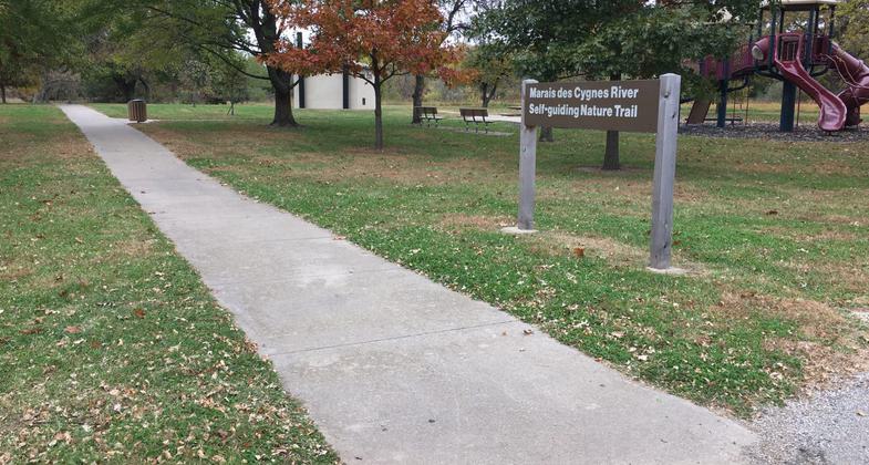
Marais de Cygnes Self-Guided Nature Trail trailhead and playground

Long Creek Suspension Bridge over the Marais de Cygnes River--a portion of the River Pond Trail and Outlet Campground Trail System
Location: The Outlet Campground Trail System is located inside the Outlet Campground on Melvern Lake near Melvern, Kansas.
- States: Kansas
- Counties: Osage
- Cities/Townships: N/A
The Outlet Campground Trail System is composed of three individual trails intertwined to provide a little over three miles of outdoor recreational trails to campers as well as the community of Osage County. This trail system provides a half-mile of paved surface accessible to the physically challenged in addition to another two and a half miles of compacted soil and smooth chert rock trail.
At the head of the trail, the Marais de Cygnes Self-Guided Nature Trail allows visitors to explore the entire oxbow that exists as a result of the Melvern Dam construction. This portion of the trail system includes the half-mile paved surface which also houses local tree identification plaques at the base of several trees along the route that add to visitor education. Connected to the paved trail is another half mile of chert gravel paths meandering around the aforementioned oxbow and eventually connecting to the Outlet River Pond Trail. The one-mile MDC Self-Guided Nature Trail features several bluebird houses that are managed in partnership with the Boy Scouts of America.
The MDC Self-Guided Nature Trail conjoins to the Outlet River Pond Trail near the entrance of the campground's C Loop. The Outlet River Pond Trail consists of a mile-and-a-half stretch of chert gravel path outlining the Outlet Campground's River Pond. This portion of the trail interconnects with several sanitary facilities and allows fishermen, hikers, and bicyclists safe access to the river pond shoreline and other park features.
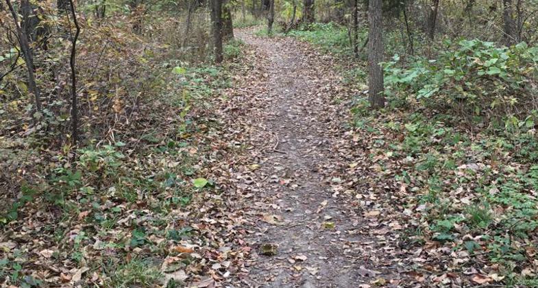
At the northeast corner of the Outlet River Pond, the River Pond Trail connects with the River Bottom Trail. The Outlet Campground's River Bottom Trail is a three-quarter-mile primitive trail that passes through an area representative of the river biosphere. Much of this portion of the trail is a compacted soil footpath only but connects to the wider chert gravel of the Outlet River Pond Trail. The River Bottom Trail houses the second and third trailheads of this system located in the C Loop of Outlet Campground.
The Outlet Campground Trail System is perfect for a variety of activities including but not limited to hiking, jogging, and biking. With much of the trail layered in smaller chert gravel, it allows for easy navigation and a solid surface to recreate on. In 2019, the Lyndon High School provided 80 sophomores with a volunteer work day in appreciation of hosting their annual Lyndon Schools Cross Country meet in the Outlet Park and on the Outlet Campground Trail System. The trails are also used heavily in the heart of the recreation season by campers in the park. Located along the trail are two playgrounds and several sanitary facilities available for our visitor's convenience.
Accessibility Information
No text provided.
Allowed Uses:
Bicycling Dogs, on leashOther Activities
- Fishing
- Wildlife viewing / observation
Public Contact
James FranzU.S. Army Corps of Engineers
31051 Melvern Lake Parkway
Melvern, KS 66510
[email protected] • (785)549-3318
Contact the trail manager for current maps and visiting details.
More Details
- Elevation (low): 971
- Elevation (high): 1002
- Elevation (cumulative): --
- Part of a Trail System? No
- Surface (primary): Rock, crushed
- Surfaces (additional): Paved, Rock, crushed, Soil
- Tread Width (average): 0"
- Tread Width (minimum): 0
- Running length (minimum): --
- Tread Grade (average, percent): --
- Tread Grade (maximum): 30
- Running length (maximum): --
- Cross-slope (average, percent): 5
- Cross-slope (maximum): --
- Running length (maximum): --
- Certified as an NRT
Oct 23, 2020


