Overmountain Victory Trail
check with the trail manager for updated details before visiting.
Overmountain Victory Trail
National Park Service
Backcountry Trail
- Length
13 miles
- Elevation Gain
--
- Route Type
out & back
- Length
13 miles - Elevation Gain
-- - Route Type
out & back
This trail is part of the federally-designated Overmountain Victory National Historic Trail. It follows the general route that patriots from the area trod to reach the Battle of Kings Mountain in October 1780.
Location: W. Kerr Scott Reservoir near Wilkesboro, NC
- States: North Carolina
- Counties: Wilkes
- Cities/Townships: Wilkesboro
This trail is part of the federally-designated Overmountain Victory National Historic Trail. It follows the general route that patriots from the area trod to reach the Battle of Kings Mountain in October 1780.
Overmountain Victory Trail was designated as a National Historic Trail by the National Park Service in 1975. An interagency partnership between the US Army Corps of Engineers and the National Park Service cooperatively manages the trail system. The Overmountain Victory Trail extends for 13 miles on the US Army Corps of Engineers public property, known as W. Kerr Scott Reservoir.
The trail is managed for multiple-use activities as designated by Congress from the Federal Land and Policy Management Act of 1976. The trail is used by the public for hiking, running, mountain biking, wildlife viewing, environmental education, fishing, and hunting. Camping is allowed only in the campgrounds, two of which are trailheads for the Overmountain Victory Trail.
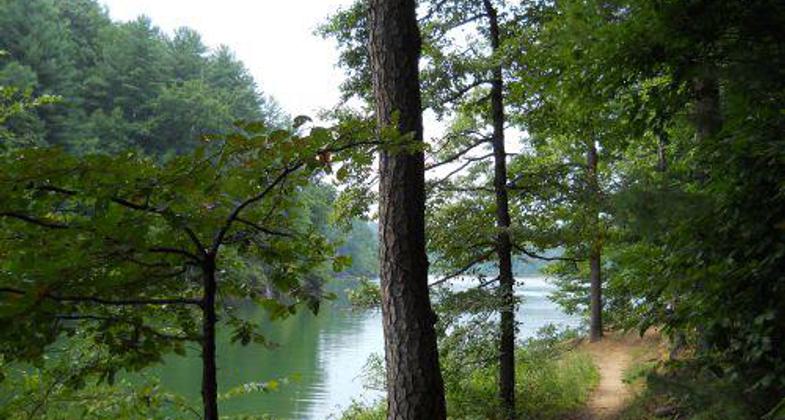
The trail begins at the Visitor's Assistance Center and travels 2 miles till it is intersected by the 2.5-mile Shiner's Run Loop. The Overmountain Victory Trail continues towards Skyline Marina where snacks and drinks may be bought. From there it continues west towards Berry Mountain Day Use Area which is equipped with restrooms, showers, drinking water, a swim beach, and picnic tables. Heading west you reach Bandit's Roost Campground where tent and RV camping is available. The total length from the Visitors Assistance Center to Bandit's Roost Campground is 7 miles. This seven-mile journey is full of scenic areas of the lake that glistens through old-growth forest. Warrior Creek Campground is another Overmountain Victory Trailhead that is approximately 2.5 miles west of Bandit's Roost Campground.
The trail flows through the campground and into Marley's Ford Wildlife Management Area. The trail is intersected twice by the Warrior Creek Trail Loop which is a 12-mile section that was completed in the year 2009. Six boardwalks have been constructed on the Overmountain Victory Trail as it flows through wetland habitats and waterfalls that wood ducks, barred owls, and bog turtles inhabit. The trail continues for 2.5 miles till it reaches the West Yadkin River Overmountain Victory Trailhead parking area. The West Yadkin River Trailhead was designed and constructed with a challenging partnership between the North Carolina Department of Environment and Natural Resources, Friends of W. Kerr Scott Lake, Brushy Mountain Cyclist Club, and the US Army Corps of Engineers.
Overmountain Victory Trail design was accomplished with the help of a local cycling club, known as the Brushy Mountain Cyclist Club, the National Parks Service, and the US Army Corps of Engineers Rangers. Construction was completed by the BMCC, and one of their members received the North Carolina State Trail Builders Award for the construction of the Overmountain Victory Trail. The BMCC works as volunteers on the project, spending many hours and days on maintenance and construction. The club holds special event races on the project in which the funds earned are expended on the trail construction and maintenance supplies and materials. Current projects include the construction of charging stations and bathrooms at the trailheads and parking lot enhancement projects at each of the trailheads.
Accessibility Information
No text provided.
Allowed Uses:
Bicycling Dogs, on leash Hiking/WalkingOther Activities
- Fishing
- Hunting
- Wildlife viewing / observation
Public Contact
Paul CarsonNational Park Service
2635 Park Rd.
Blacksburg, SC 29702
[email protected] • (864) 936-3477
Contact the trail manager for current maps and visiting details.
More Details
- Elevation (low): 1032
- Elevation (high): 1080
- Elevation (cumulative): --
- Part of a Trail System? No
- National Designations: National Historic Trail
- Surface (primary): Soil
- Surfaces (additional): Boardwalk, Rock, boulders, Rock, smooth, Soil
- Tread Width (average): 36"
- Tread Width (minimum): 16
- Running length (minimum): --
- Tread Grade (average, percent): 2
- Tread Grade (maximum): 7
- Running length (maximum): --
- Cross-slope (average, percent): 1
- Cross-slope (maximum): --
- Running length (maximum): --
- Certified as an NRT
May 29, 2012


